
 Maureville
Samoëns
Gréning
Toulouse
Volx
Goudet
Méhoncourt
Saint-Hymer
Pontcarré
Maureville
Samoëns
Gréning
Toulouse
Volx
Goudet
Méhoncourt
Saint-Hymer
Pontcarré
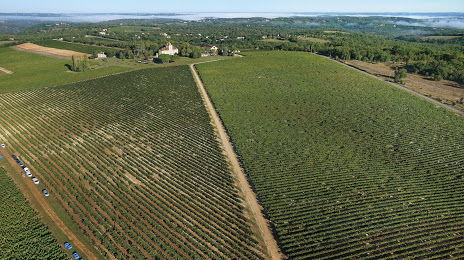
Château de Haute-Serre on the map, Cahors, France
Photo
Where is located Château de Haute-Serre
Château de Haute-Serre — local attraction, which is located at Château de Haute-Serre, 46230 Cieurac, France and belongs to the category — winery. Average visitor rating for this place — 4.7 (according to 51 rating, information from open sources and relevant for 2022).
Exact location — Château de Haute-Serre, marked on the map with a red marker.
You can get directions to Château de Haute-Serre on the map from your location.
What else is interesting in Cahors? You can see all the sights if you go to the city page.
Coordinates
Château de Haute-Serre, France coordinates in decimal format: latitude — 44.38986844517868, longitude — 1.4906309978883034. When converted to degrees, minutes, seconds Château de Haute-Serre has the following coordinates: 44°23′23.53 north latitude and 1°29′26.27 east longitude.
Nearby cities
The largest cities that are located nearby:
- Toulouse — 93 km
- Limoges — 154 km
- Bordeaux — 164 km
- Clermont-Ferrand — 194 km
- Montpellier — 216 km
- Perpignan — 227 km
- Nimes — 242 km
- Saint-Étienne — 253 km
- Lyon — 300 km
- San Sebastián
 (Spain) — 302 km
 - Villeurbanne — 304 km
- Pamplona (Spain) — 309 km
- Lleida (Spain) — 320 km
- Terrassa (Spain) — 322 km
- Sabadell (Spain) — 325 km
- Tours — 331 km
- Mataró (Spain) — 332 km
- Aix-en-Provence — 337 km
- Santa Coloma de Gramenet (Spain) — 338 km
Distance to the capital
Distance to the capital (Paris) is about — 501 km.