
 Maureville
Samoëns
Gréning
Toulouse
Volx
Goudet
Méhoncourt
Saint-Hymer
Pontcarré
Maureville
Samoëns
Gréning
Toulouse
Volx
Goudet
Méhoncourt
Saint-Hymer
Pontcarré
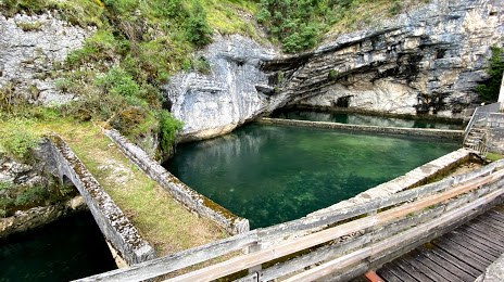
Fontaine des Chartreux on the map, Cahors, France
Photo
Where is located Fontaine des Chartreux
Fontaine des Chartreux — local attraction, which is located at 914 Chem. de la Chartreuse, 46000 Cahors, France and belongs to the category — tourist attraction. Average visitor rating for this place — 4.4 (according to 22 ratings, information from open sources and relevant for 2022).
Exact location — Fontaine des Chartreux, marked on the map with a red marker.
You can get directions to Fontaine des Chartreux on the map from your location.
What else is interesting in Cahors? You can see all the sights if you go to the city page.
Coordinates
Fontaine des Chartreux, France coordinates in decimal format: latitude — 44.44252617968243, longitude — 1.431892297890031. When converted to degrees, minutes, seconds Fontaine des Chartreux has the following coordinates: 44°26′33.09 north latitude and 1°25′54.81 east longitude.
Nearby cities
The largest cities that are located nearby:
- Toulouse — 93 km
- Limoges — 154 km
- Bordeaux — 164 km
- Clermont-Ferrand — 194 km
- Montpellier — 216 km
- Perpignan — 227 km
- Nimes — 242 km
- Saint-Étienne — 253 km
- Lyon — 300 km
- San Sebastián
 (Spain) — 302 km
 - Villeurbanne — 304 km
- Pamplona (Spain) — 309 km
- Lleida (Spain) — 320 km
- Terrassa (Spain) — 322 km
- Sabadell (Spain) — 325 km
- Tours — 331 km
- Mataró (Spain) — 332 km
- Aix-en-Provence — 337 km
- Santa Coloma de Gramenet (Spain) — 338 km
Distance to the capital
Distance to the capital (Paris) is about — 496 km.