
 Maureville
Samoëns
Gréning
Toulouse
Volx
Goudet
Méhoncourt
Saint-Hymer
Pontcarré
Maureville
Samoëns
Gréning
Toulouse
Volx
Goudet
Méhoncourt
Saint-Hymer
Pontcarré
Plage des 4 sardines on the map, Concarneau, France
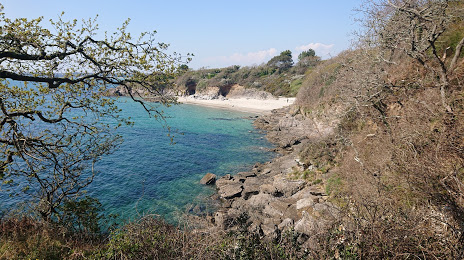
Photo
Where is located Plage des 4 sardines
Plage des 4 sardines — local attraction, which is located at Chem. de Lanadan, 29900 Concarneau, France and belongs to the category — tourist attraction. Average visitor rating for this place — 4.6 (according to 131 rating, information from open sources and relevant for 2022).
Exact location — Plage des 4 sardines, marked on the map with a red marker.
You can get directions to Plage des 4 sardines on the map from your location.
What else is interesting in Concarneau? You can see all the sights if you go to the city page.
Coordinates
Plage des 4 sardines, France coordinates in decimal format: latitude — 47.886923505647836, longitude — -3.945699101993221. When converted to degrees, minutes, seconds Plage des 4 sardines has the following coordinates: 47°53′12.92 north latitude and -3°56′44.52 east longitude.
Nearby cities
The largest cities that are located nearby:
- Brest — 71 km
- Rennes — 168 km
- Nantes — 192 km
- Angers — 255 km
- Caen — 295 km
- Le Mans — 305 km
- Exeter
 (United Kingdom) — 316 km
 - Le Havre — 340 km
- Bournemouth (United Kingdom) — 346 km
- Tours — 349 km
- Southampton (United Kingdom) — 379 km
- Portsmouth (United Kingdom) — 381 km
- Rouen — 401 km
- Bristol (Great Britain) — 407 km
- Bordeaux — 426 km
- Orléans — 432 km
- Swindon (United Kingdom) — 433 km
- Eastbourne (United Kingdom) — 435 km
- Crawley (United Kingdom) — 442 km
Distance to the capital
Distance to the capital (Paris) is about — 478 km.