
 Maureville
Samoëns
Gréning
Toulouse
Volx
Goudet
Méhoncourt
Saint-Hymer
Pontcarré
Maureville
Samoëns
Gréning
Toulouse
Volx
Goudet
Méhoncourt
Saint-Hymer
Pontcarré
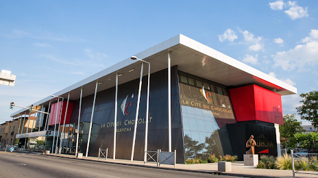
Cite du Chocolat Valrhona on the map, Tournon-sur-Rhône, France
Photo
Where is located Cite du Chocolat Valrhona
Cite du Chocolat Valrhona — local attraction, which is located at 12 Av. du Président Roosevelt, 26600 Tain-l'Hermitage, France and belongs to the category — museum. Average visitor rating for this place — - (according to 3897 ratings, information from open sources and relevant for 2022).
Exact location — Cite du Chocolat Valrhona, marked on the map with a red marker.
You can get directions to Cite du Chocolat Valrhona on the map from your location.
What else is interesting in Tournon-sur-Rhône? You can see all the sights if you go to the city page.
Coordinates
Cite du Chocolat Valrhona, France coordinates in decimal format: latitude — 45.06847969231135, longitude — 4.8435909979107326. When converted to degrees, minutes, seconds Cite du Chocolat Valrhona has the following coordinates: 45°4′6.53 north latitude and 4°50′36.93 east longitude.
Nearby cities
The largest cities that are located nearby:
- Saint-Étienne — 54 km
- Grenoble — 71 km
- Lyon — 77 km
- Villeurbanne — 78 km
- Nimes — 141 km
- Clermont-Ferrand — 156 km
- Geneva
 (Switzerland) — 160 km
 - Aix-en-Provence — 177 km
- Montpellier — 178 km
- Marseille — 201 km
- Lausanne (Switzerland) — 211 km
- Turin
 (Italy) — 223 km
 - Toulon — 232 km
- Nice — 245 km
- Dijon — 250 km
- Besançon — 256 km
- Bern (Switzerland) — 287 km
- Limoges — 288 km
- Novara (Italy) — 297 km
Distance to the capital
Distance to the capital (Paris) is about — 462 km.