
 Maureville
Samoëns
Gréning
Toulouse
Volx
Goudet
Méhoncourt
Saint-Hymer
Pontcarré
Maureville
Samoëns
Gréning
Toulouse
Volx
Goudet
Méhoncourt
Saint-Hymer
Pontcarré
Étang des Périseaux on the map, Ronchin, France
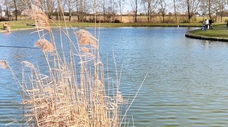
Photo
Where is located Étang des Périseaux
Étang des Périseaux — local attraction, which is located at 59155 Faches-Thumesnil, France and belongs to the category — fishing pond. Average visitor rating for this place — 4.2 (according to 44 ratings, information from open sources and relevant for 2022).
Exact location — Étang des Périseaux, marked on the map with a red marker.
You can get directions to Étang des Périseaux on the map from your location.
What else is interesting in Ronchin? You can see all the sights if you go to the city page.
Coordinates
Étang des Périseaux, France coordinates in decimal format: latitude — 50.58495671902661, longitude — 3.068658298102794. When converted to degrees, minutes, seconds Étang des Périseaux has the following coordinates: 50°35′5.84 north latitude and 3°4′7.17 east longitude.
Nearby cities
The largest cities that are located nearby:
- Lille — 3 km
- Brussels
 (Belgium) — 93 km
 - Amiens — 96 km
- Charleroi (Belgium) — 99 km
- Antwerp (Belgium) — 114 km
- Namur (Belgium) — 127 km
- Breda
 (Netherlands) — 159 km
 - Reims — 164 km
- Dordrecht (Netherlands) — 173 km
- Tilburg (Netherlands) — 174 km
- Rotterdam (Netherlands) — 174 km
- Liège (Belgium) — 175 km
- The Hague (Netherlands) — 182 km
- Maastricht (Netherlands) — 184 km
- Zoetermeer (Netherlands) — 187 km
- Eindhoven (Netherlands) — 189 km
- Rouen — 192 km
- Southend-on-Sea
 (United Kingdom) — 193 km
 - 's-Hertogenbosch (Netherlands) — 194 km
Distance to the capital
Distance to the capital (Paris) is about — 199 km.