
 Maureville
Samoëns
Gréning
Toulouse
Volx
Goudet
Méhoncourt
Saint-Hymer
Pontcarré
Maureville
Samoëns
Gréning
Toulouse
Volx
Goudet
Méhoncourt
Saint-Hymer
Pontcarré
Barre de Cuers on the map, Brignoles, France
Photo
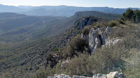
Where is located Barre de Cuers
Barre de Cuers — local attraction, which is located at 705 m and belongs to the category — -. Average visitor rating for this place — 4.7 (according to 6 ratings, information from open sources and relevant for 2022).
Exact location — Barre de Cuers, marked on the map with a red marker.
You can get directions to Barre de Cuers on the map from your location.
What else is interesting in Brignoles? You can see all the sights if you go to the city page.
Coordinates
Barre de Cuers, France coordinates in decimal format: latitude — 43.28551871490744, longitude — 6.059721873268656. When converted to degrees, minutes, seconds Barre de Cuers has the following coordinates: 43°17′7.87 north latitude and 6°3′35 east longitude.
Nearby cities
The largest cities that are located nearby:
- Toulon — 33 km
- Aix-en-Provence — 51 km
- Marseille — 57 km
- Nice — 102 km
- Nimes — 144 km
- Montpellier — 176 km
- Grenoble — 199 km
- Turin
 (Italy) — 223 km
 - Genoa (Italy) — 253 km
- Saint-Étienne — 260 km
- Perpignan — 269 km
- Villeurbanne — 277 km
- Lyon — 277 km
- Novara (Italy) — 301 km
- Geneva
 (Switzerland) — 309 km
 - Milan (Italy) — 332 km
- Livorno (Italy) — 341 km
- Monza (Italy) — 346 km
- Lausanne (Switzerland) — 347 km
Distance to the capital
Distance to the capital (Paris) is about — 682 km.