
 Maureville
Samoëns
Gréning
Toulouse
Volx
Goudet
Méhoncourt
Saint-Hymer
Pontcarré
Maureville
Samoëns
Gréning
Toulouse
Volx
Goudet
Méhoncourt
Saint-Hymer
Pontcarré
Ouvrage Bois-du-Four on the map, Longwy, France
Photo
Where is located Ouvrage Bois-du-Four
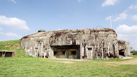
Ouvrage Bois-du-Four — local attraction, which is located at Unnamed Road, 54920, Villers-la-Montagne, France and belongs to the category — museum. Average visitor rating for this place — 4.6 (according to 17 ratings, information from open sources and relevant for 2022).
Exact location — Ouvrage Bois-du-Four, marked on the map with a red marker.
You can get directions to Ouvrage Bois-du-Four on the map from your location.
What else is interesting in Longwy? You can see all the sights if you go to the city page.
Coordinates
Ouvrage Bois-du-Four, France coordinates in decimal format: latitude — 49.457619210092375, longitude — 5.843689598062162. When converted to degrees, minutes, seconds Ouvrage Bois-du-Four has the following coordinates: 49°27′27.43 north latitude and 5°50′37.28 east longitude.
Nearby cities
The largest cities that are located nearby:
- Metz — 53 km
- Trier
 (Germany) — 68 km
 - Saarbrücken (Germany) — 94 km
- Nancy — 97 km
- Namur
 (Belgium) — 122 km
 - Liège (Belgium) — 124 km
- Reims — 128 km
- Charleroi (Belgium) — 135 km
- Aachen (Germany) — 141 km
- Maastricht
 (Netherlands) — 147 km
 - Koblenz (Germany) — 159 km
- Bonn (Germany) — 164 km
- Brussels (Belgium) — 177 km
- Cologne (Germany) — 178 km
- Strasbourg — 179 km
- Mainz (Germany) — 184 km
- Wiesbaden (Germany) — 186 km
- Bergisch Gladbach (Germany) — 189 km
- Mönchengladbach (Germany) — 190 km
Distance to the capital
Distance to the capital (Paris) is about — 263 km.