
 Maureville
Samoëns
Gréning
Toulouse
Volx
Goudet
Méhoncourt
Saint-Hymer
Pontcarré
Maureville
Samoëns
Gréning
Toulouse
Volx
Goudet
Méhoncourt
Saint-Hymer
Pontcarré
Chapelle saint-Lupien on the map, Bouguenais, France
Photo
Where is located Chapelle saint-Lupien
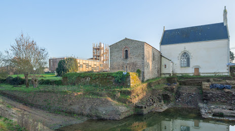
Chapelle saint-Lupien — local attraction, which is located at 21 Rue Saint-Lupien, 44400 Rezé, France and belongs to the category — chapel. Average visitor rating for this place — 4.9 (according to 7 ratings, information from open sources and relevant for 2022).
Exact location — Chapelle saint-Lupien, marked on the map with a red marker.
You can get directions to Chapelle saint-Lupien on the map from your location.
What else is interesting in Bouguenais? You can see all the sights if you go to the city page.
Coordinates
Chapelle saint-Lupien, France coordinates in decimal format: latitude — 47.191946425568474, longitude — -1.5656718020173075. When converted to degrees, minutes, seconds Chapelle saint-Lupien has the following coordinates: 47°11′31.01 north latitude and -1°33′56.42 east longitude.
Nearby cities
The largest cities that are located nearby:
- Nantes — 7 km
- Angers — 86 km
- Rennes — 104 km
- Le Mans — 163 km
- Tours — 174 km
- Caen — 239 km
- Brest — 250 km
- Limoges — 267 km
- Bordeaux — 271 km
- Orléans — 274 km
- Le Havre — 285 km
- Rouen — 318 km
- Boulogne-Billancourt — 336 km
- Bournemouth
 (United Kingdom) — 392 km
 - Clermont-Ferrand — 395 km
- Portsmouth (United Kingdom) — 405 km
- Amiens — 410 km
- Southampton (United Kingdom) — 413 km
- Exeter (United Kingdom) — 414 km
Distance to the capital
Distance to the capital (Paris) is about — 345 km.