
 Maureville
Samoëns
Gréning
Toulouse
Volx
Goudet
Méhoncourt
Saint-Hymer
Pontcarré
Maureville
Samoëns
Gréning
Toulouse
Volx
Goudet
Méhoncourt
Saint-Hymer
Pontcarré
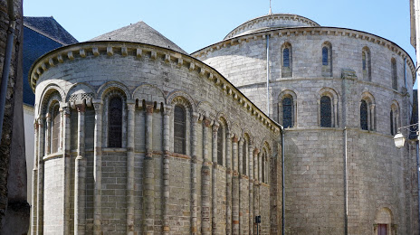
Abbaye de Sainte-Croix on the map, Quimperlé, France
Photo
Where is located Abbaye de Sainte-Croix
Abbaye de Sainte-Croix — local attraction, which is located at 2 Rue Ellé, 29300 Quimperlé, France and belongs to the category — catholic church. Average visitor rating for this place — 4.3 (according to 211 ratings, information from open sources and relevant for 2022).
Exact location — Abbaye de Sainte-Croix, marked on the map with a red marker.
You can get directions to Abbaye de Sainte-Croix on the map from your location.
What else is interesting in Quimperlé? You can see all the sights if you go to the city page.
Coordinates
Abbaye de Sainte-Croix, France coordinates in decimal format: latitude — 47.87244039558887, longitude — -3.545119601993732. When converted to degrees, minutes, seconds Abbaye de Sainte-Croix has the following coordinates: 47°52′20.79 north latitude and -3°32′42.43 east longitude.
Nearby cities
The largest cities that are located nearby:
- Brest — 90 km
- Rennes — 141 km
- Nantes — 166 km
- Angers — 227 km
- Caen — 271 km
- Le Mans — 278 km
- Exeter
 (United Kingdom) — 315 km
 - Le Havre — 318 km
- Tours — 321 km
- Bournemouth (United Kingdom) — 336 km
- Southampton (United Kingdom) — 368 km
- Portsmouth (United Kingdom) — 368 km
- Rouen — 377 km
- Bristol (Great Britain) — 401 km
- Orléans — 404 km
- Bordeaux — 408 km
- Eastbourne (United Kingdom) — 418 km
- Swindon (United Kingdom) — 425 km
- Crawley (United Kingdom) — 427 km
Distance to the capital
Distance to the capital (Paris) is about — 449 km.