
 Maureville
Samoëns
Gréning
Toulouse
Volx
Goudet
Méhoncourt
Saint-Hymer
Pontcarré
Maureville
Samoëns
Gréning
Toulouse
Volx
Goudet
Méhoncourt
Saint-Hymer
Pontcarré
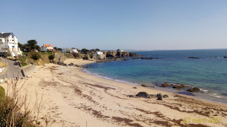
Plage des Grands Sables on the map, Quimperlé, France
Photo
Where is located Plage des Grands Sables
Plage des Grands Sables — local attraction, which is located at no data and belongs to the category — -. Average visitor rating for this place — 4.4 (according to 30 ratings, information from open sources and relevant for 2022).
Exact location — Plage des Grands Sables, marked on the map with a red marker.
You can get directions to Plage des Grands Sables on the map from your location.
What else is interesting in Quimperlé? You can see all the sights if you go to the city page.
Coordinates
Plage des Grands Sables, France coordinates in decimal format: latitude — 47.76571447153464, longitude — -3.547644051997468. When converted to degrees, minutes, seconds Plage des Grands Sables has the following coordinates: 47°45′56.57 north latitude and -3°32′51.52 east longitude.
Nearby cities
The largest cities that are located nearby:
- Brest — 90 km
- Rennes — 141 km
- Nantes — 166 km
- Angers — 227 km
- Caen — 271 km
- Le Mans — 278 km
- Exeter
 (United Kingdom) — 315 km
 - Le Havre — 318 km
- Tours — 321 km
- Bournemouth (United Kingdom) — 336 km
- Southampton (United Kingdom) — 368 km
- Portsmouth (United Kingdom) — 368 km
- Rouen — 377 km
- Bristol (Great Britain) — 401 km
- Orléans — 404 km
- Bordeaux — 408 km
- Eastbourne (United Kingdom) — 418 km
- Swindon (United Kingdom) — 425 km
- Crawley (United Kingdom) — 427 km
Distance to the capital
Distance to the capital (Paris) is about — 453 km.