West Covina — Grove
West Covina — Britt
West Covina — Scottsburg
West Covina — McBee
West Covina — New York
West Covina — Eupora
West Covina — El Paso
West Covina — Perris
West Covina — Glennallen
West Covina — Arimo
West Covina — Carroll County
West Covina — Sharon Grove
West Covina — Mills River
West Covina — Hawarden
West Covina — San Rafael
West Covina — Chestertown
West Covina — Raymond
West Covina — Peoria
West Covina — Fort Oglethorpe
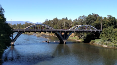
West Covina — Grants Pass distance, route on the map
Distance by car
Distance between West Covina, California, United States and Grants Pass, Oregon, United States by car is — km, or miles. To travel this distance by car, you need minute, or h.
Route on the map, driving directions
Car route West Covina — Grants Pass was created automatically. The road on the map is shown as a blue line. By moving the markers, you can create a new route through the points you need.
Distance by plane
If you decide to take a trip West Covina Grants Pass by plane, then you have to fly the distance — 1043 km or 647 miles. It is marked on the map with a gray line (between two points in a straight line).
Flight time
Estimated flight time West Covina Grants Pass by plane at cruising speed 750 km / h will be — 1 h. and 23 min.
Direction of movement
United States, West Covina — right-hand traffic. United States, Grants Pass — right-hand traffic.
Difference in time
West Covina and Grants Pass are in the same time zone. Between them there is no time difference (UTC -7 America/Los_Angeles).
Interesting Facts
Information on alternative ways to get to your destination.
The length of this distance is about 2.6% of the total length of the equator.
The percentage of the population is clearly shown in the graph:
West Covina — 109,756, Grants Pass — 27,191 residents (less by 82,565).
The cost of travel
Calculate the cost of the trip yourself using the fuel consumption calculator, changing the data in the table.
Calculate the cost of other distances from the starting point — West Covina.