Izbat as Sarayah Al Kabirah — Balyana
Izbat as Sarayah Al Kabirah — Taj Al Izz
Izbat as Sarayah Al Kabirah — Al Sadiyyin
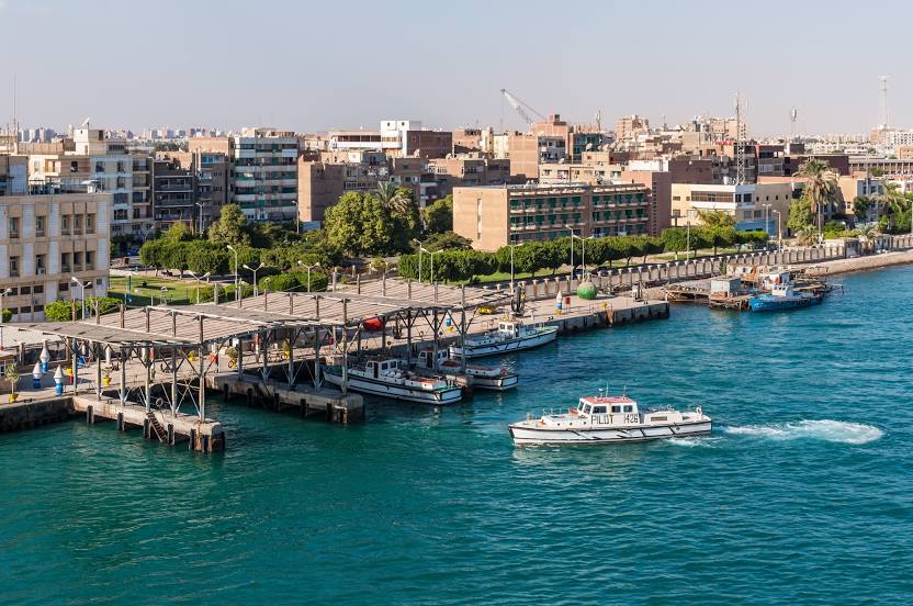
Izbat as Sarayah Al Kabirah — The Red Sea
Izbat as Sarayah Al Kabirah — Sahrajt Al Kubra
Izbat as Sarayah Al Kabirah — As Sibaiyyah
Izbat as Sarayah Al Kabirah — Kafr El-Saedy
Izbat as Sarayah Al Kabirah — Al Waqf
Izbat as Sarayah Al Kabirah — Mishayrif
Izbat as Sarayah Al Kabirah — Helis
Izbat as Sarayah Al Kabirah — El-Usayrat
Izbat as Sarayah Al Kabirah — Zamalek
Izbat as Sarayah Al Kabirah — Port Fuad
Izbat as Sarayah Al Kabirah — Shanasha
Izbat as Sarayah Al Kabirah — Ezbet Youssef Abou Salamah
Izbat as Sarayah Al Kabirah — Dmro
Izbat as Sarayah Al Kabirah — Markaz Nasr
Izbat as Sarayah Al Kabirah — Bhbah
Damshit
Western
Ezbet Saleh Farid
AR Rajdiyyah
Sibirbay
Tanta
Kafr Sibtas
Mitt tribal Hbeich
Poke
Mit Ghazal
Abu Mashhur
Janzur
Shintina Al Hajar
Seven pools
Tukh Tanbisha
Quwaisna Airport
Abnahs
Quwaysna
Arabs sand
Banha
Damallu
Kafr Mouse
Shiblanjah
Qateifat Al Azizeyah
Sanhut Al Birak
Tombs
Kafr Mit Soheil
Mit Suhayl
Mit Gabir
Shubra an Nakhlah
Ezbet Abou Hamid
As Saidyyah
Markaz Belbes
Al Adliyyah
Ezbet Arab El-Saida
Gate 2 Cairo
New Heliopolis City
Cairo
Badr City
Agrod
Izbat as Sarayah Al Kabirah — Balyana
Izbat as Sarayah Al Kabirah — Taj Al Izz
Izbat as Sarayah Al Kabirah — Al Sadiyyin
Izbat as Sarayah Al Kabirah — The Red Sea
Izbat as Sarayah Al Kabirah — Sahrajt Al Kubra
Izbat as Sarayah Al Kabirah — As Sibaiyyah
Izbat as Sarayah Al Kabirah — Kafr El-Saedy
Izbat as Sarayah Al Kabirah — Al Waqf
Izbat as Sarayah Al Kabirah — Mishayrif
Izbat as Sarayah Al Kabirah — Helis
Izbat as Sarayah Al Kabirah — El-Usayrat
Izbat as Sarayah Al Kabirah — Zamalek
Izbat as Sarayah Al Kabirah — Port Fuad
Izbat as Sarayah Al Kabirah — Shanasha
Izbat as Sarayah Al Kabirah — Ezbet Youssef Abou Salamah
Izbat as Sarayah Al Kabirah — Dmro
Izbat as Sarayah Al Kabirah — Markaz Nasr
Izbat as Sarayah Al Kabirah — Bhbah
Damshit
Western
Ezbet Saleh Farid
AR Rajdiyyah
Sibirbay
Tanta
Kafr Sibtas
Mitt tribal Hbeich
Poke
Mit Ghazal
Abu Mashhur
Janzur
Shintina Al Hajar
Seven pools
Tukh Tanbisha
Quwaisna Airport
Abnahs
Quwaysna
Arabs sand
Banha
Damallu
Kafr Mouse
Shiblanjah
Qateifat Al Azizeyah
Sanhut Al Birak
Tombs
Kafr Mit Soheil
Mit Suhayl
Mit Gabir
Shubra an Nakhlah
Ezbet Abou Hamid
As Saidyyah
Markaz Belbes
Al Adliyyah
Ezbet Arab El-Saida
Gate 2 Cairo
New Heliopolis City
Cairo
Badr City
Agrod
Izbat as Sarayah Al Kabirah — Suez distance, route on the map
Distance by car
Distance between Izbat as Sarayah Al Kabirah, Gharbia Governorate, Egypt and Suez, Suez Governorate, Egypt by car is — km, or miles. To travel this distance by car, you need minute, or h.
Route on the map, driving directions
Car route Izbat as Sarayah Al Kabirah — Suez was created automatically. The road on the map is shown as a blue line. By moving the markers, you can create a new route through the points you need.
Passing cities through which the car route passes: Kom Ali, Damshit, Western, Ezbet Saleh Farid, AR Rajdiyyah, Sibirbay, Tanta, Kafr Sibtas, Mitt tribal Hbeich, Poke, Mit Ghazal, Abu Mashhur, Janzur, Shintina Al Hajar, Seven pools, Tukh Tanbisha, Quwaisna Airport, Abnahs, Quwaysna, Arabs sand, Banha, Damallu, Kafr Mouse, Shiblanjah, Qateifat Al Azizeyah, Sanhut Al Birak, Tombs, Kafr Mit Soheil, Mit Suhayl, Mit Gabir, Shubra an Nakhlah, Ezbet Abou Hamid, As Saidyyah, Markaz Belbes, Al Adliyyah, Ezbet Arab El-Saida, Gate 2 Cairo, New Heliopolis City, Cairo, Badr City, Agrod.
Distance by plane
If you decide to take a trip Izbat as Sarayah Al Kabirah Suez by plane, then you have to fly the distance — 187 km or 116 miles. It is marked on the map with a gray line (between two points in a straight line).
Flight time
Estimated flight time Izbat as Sarayah Al Kabirah Suez by plane at cruising speed 750 km / h will be — 14 min.
Direction of movement
Egypt, Izbat as Sarayah Al Kabirah — right-hand traffic. Egypt, Suez — right-hand traffic.
Difference in time
Izbat as Sarayah Al Kabirah and Suez are in the same time zone. Between them there is no time difference (UTC +2 Africa/Cairo).
Interesting Facts
Information on alternative ways to get to your destination.
The length of this distance is about 0.5% of the total length of the equator.
The cost of travel
Calculate the cost of the trip yourself using the fuel consumption calculator, changing the data in the table.