Huta Krzeszowska — Mogilno
Huta Krzeszowska — Jaroslav
Huta Krzeszowska — Pabianice
Huta Krzeszowska — Dzierzgów
Huta Krzeszowska — Chodziez
Huta Krzeszowska — Sierpc
Huta Krzeszowska — Kuryłówka
Huta Krzeszowska — Ostaszewo
Huta Krzeszowska — Konary
Huta Krzeszowska — Mragowo
Huta Krzeszowska — Srokowo
Huta Krzeszowska — Ustroń
Huta Krzeszowska — Szamocin
Huta Krzeszowska — Liw
Huta Krzeszowska — Sulecin
Huta Krzeszowska — Żukowice
Huta Krzeszowska — Korsze
Huta Krzeszowska — Grabowo
Huta Krzeszowska — Jejkowice
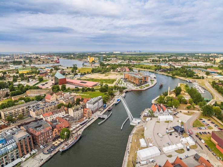
Huta Krzeszowska — Tczew distance, route on the map
Distance by car
Distance between Huta Krzeszowska, Podkarpackie Voivodeship, Poland and Tczew, Pomeranian Voivodeship, Poland by car is — km, or miles. To travel this distance by car, you need minute, or h.
Route on the map, driving directions
Car route Huta Krzeszowska — Tczew was created automatically. The road on the map is shown as a blue line. By moving the markers, you can create a new route through the points you need.
Distance by plane
If you decide to take a trip Huta Krzeszowska Tczew by plane, then you have to fly the distance — 469 km or 291 miles. It is marked on the map with a gray line (between two points in a straight line).
Flight time
Estimated flight time Huta Krzeszowska Tczew by plane at cruising speed 750 km / h will be — 37 min.
Direction of movement
Poland, Huta Krzeszowska — right-hand traffic. Poland, Tczew — right-hand traffic.
Difference in time
Huta Krzeszowska and Tczew are in the same time zone. Between them there is no time difference (UTC +2 Europe/Warsaw).
Interesting Facts
Information on alternative ways to get to your destination.
The length of this distance is about 1.2% of the total length of the equator.
The cost of travel
Calculate the cost of the trip yourself using the fuel consumption calculator, changing the data in the table.