
 Mikhaylovka
Dyrestuy
Mikhaylovka
Mayskiy
Novobessergenevka
Tersky District
Lesnoy
Tertezh
Kuz'minskiye Otverzhki
Mikhaylovka
Dyrestuy
Mikhaylovka
Mayskiy
Novobessergenevka
Tersky District
Lesnoy
Tertezh
Kuz'minskiye Otverzhki
Pamyatnik Truzhenikam Tyla on the map, Omsk, Russian Federation
Photo
Where is located Pamyatnik Truzhenikam Tyla
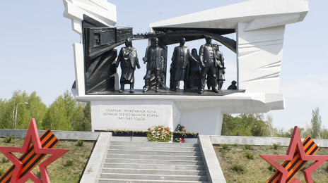
Pamyatnik Truzhenikam Tyla — local attraction, which is located at Ulitsa Bogdana Khmel'nitskogo, 223, Omsk, Omsk Oblast, 644021 and belongs to the category — historical landmark. Average visitor rating for this place — 4.9 (according to 26 ratings, information from open sources and relevant for 2022).
Exact location — Pamyatnik Truzhenikam Tyla, marked on the map with a red marker.
You can get directions to Pamyatnik Truzhenikam Tyla on the map from your location.
What else is interesting in Omsk? You can see all the sights if you go to the city page.
Coordinates
Pamyatnik Truzhenikam Tyla, Russian Federation coordinates in decimal format: latitude — 54.96711721359278, longitude — 73.41487839842515. When converted to degrees, minutes, seconds Pamyatnik Truzhenikam Tyla has the following coordinates: 54°58′1.62 north latitude and 73°24′53.56 east longitude.
Nearby cities
The largest cities that are located nearby:
- Kokshetau
 (Kazakhstan) — 322 km
 - Ekibastuz (Kazakhstan) — 384 km
- Pavlodar (Kazakhstan) — 385 km
- Kurgan — 505 km
- Tyumen — 528 km
- Temirtau (Kazakhstan) — 546 km
- Novosibirsk — 607 km
- Rubtsovsk — 661 km
- Kostanay (Kazakhstan) — 673 km
- Nefteyugansk — 677 km
- Nizhnevartovsk — 681 km
- Surgut — 693 km
- Semey (Kazakhstan) — 700 km
- Barnaul — 710 km
- Seversk — 721 km
- Tomsk — 729 km
- Chelyabinsk — 754 km
- Yekaterinburg — 799 km
- Leninsk-Kuznetskiy — 819 km
Distance to the capital
Distance to the capital (Moscow) is about — 2240 km.