
 Mikhaylovka
Dyrestuy
Mikhaylovka
Mayskiy
Novobessergenevka
Tersky District
Lesnoy
Tertezh
Kuz'minskiye Otverzhki
Mikhaylovka
Dyrestuy
Mikhaylovka
Mayskiy
Novobessergenevka
Tersky District
Lesnoy
Tertezh
Kuz'minskiye Otverzhki
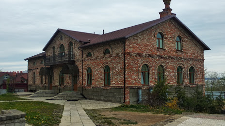
Svyato-Serafimovskiy Monastyr' on the map, Vladivostok, Russian Federation
Photo
Where is located Svyato-Serafimovskiy Monastyr'
Svyato-Serafimovskiy Monastyr' — local attraction, which is located at Russkiy, Primorsky Krai, 690922 and belongs to the category — monastery. Average visitor rating for this place — 4.7 (according to 183 ratings, information from open sources and relevant for 2022).
Exact location — Svyato-Serafimovskiy Monastyr', marked on the map with a red marker.
You can get directions to Svyato-Serafimovskiy Monastyr' on the map from your location.
What else is interesting in Vladivostok? You can see all the sights if you go to the city page.
Coordinates
Svyato-Serafimovskiy Monastyr', Russian Federation coordinates in decimal format: latitude — 43.04397154189072, longitude — 131.82169829800299. When converted to degrees, minutes, seconds Svyato-Serafimovskiy Monastyr' has the following coordinates: 43°2′38.3 north latitude and 131°49′18.11 east longitude.
Nearby cities
The largest cities that are located nearby:
- Artem — 35 km
- Ussuriysk — 74 km
- Nakhodka — 86 km
- Mudanjiang
 (China) — 238 km
 - Jixi (China) — 250 km
- Jiamusi (China) — 423 km
- Jilin (China) — 434 km
- Hegang (China) — 481 km
- Harbin (China) — 508 km
- Changchun (China) — 530 km
- Suihua (China) — 540 km
- Liaoyuan (China) — 548 km
- Siping (China) — 609 km
- Khabarovsk — 637 km
- Daqing (China) — 642 km
- Fushun (China) — 668 km
- Tieling (China) — 677 km
- Pyongyang
 (North Korea) — 695 km
 - Benxi (China) — 704 km
Distance to the capital
Distance to the capital (Moscow) is about — 6420 km.