
 Mikhaylovka
Dyrestuy
Mikhaylovka
Mayskiy
Novobessergenevka
Tersky District
Lesnoy
Tertezh
Kuz'minskiye Otverzhki
Mikhaylovka
Dyrestuy
Mikhaylovka
Mayskiy
Novobessergenevka
Tersky District
Lesnoy
Tertezh
Kuz'minskiye Otverzhki
Bunker-42 on Taganka on the map, Moscow, Russian Federation
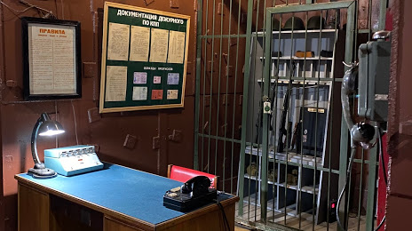
Photo
Where is located Bunker-42 on Taganka
Bunker-42 on Taganka — local attraction, which is located at 5-Y Kotel'nicheskiy Pereulok, д.11, Moscow, 115172 and belongs to the category — museum. Average visitor rating for this place — 4.5 (according to 1816 ratings, information from open sources and relevant for 2022).
Exact location — Bunker-42 on Taganka, marked on the map with a red marker.
You can get directions to Bunker-42 on Taganka on the map from your location.
What else is interesting in Moscow? You can see all the sights if you go to the city page.
Coordinates
Bunker-42 on Taganka, Russian Federation coordinates in decimal format: latitude — 55.741868209065004, longitude — 37.64917579845501. When converted to degrees, minutes, seconds Bunker-42 on Taganka has the following coordinates: 55°44′30.73 north latitude and 37°38′57.03 east longitude.
Nearby cities
The largest cities that are located nearby:
- Khimki — 19 km
- Lyubertsy — 19 km
- Izmaylovo — 21 km
- Balashikha — 23 km
- Odintsovo — 24 km
- Pushkino — 30 km
- Podolsk — 36 km
- Zelenograd — 38 km
- Elektrostal — 53 km
- Noginsk — 54 km
- Orekhovo-Zuyevo — 84 km
- Serpukhov — 93 km
- Obninsk — 96 km
- Kolomna — 103 km
- Kaluga — 158 km
- Tver — 159 km
- Tula — 171 km
- Vladimir — 178 km
- Ryazan — 185 km