
 Mikhaylovka
Dyrestuy
Mikhaylovka
Mayskiy
Novobessergenevka
Tersky District
Lesnoy
Tertezh
Kuz'minskiye Otverzhki
Mikhaylovka
Dyrestuy
Mikhaylovka
Mayskiy
Novobessergenevka
Tersky District
Lesnoy
Tertezh
Kuz'minskiye Otverzhki
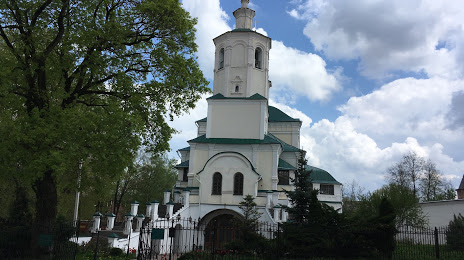
Spaso-Preobrazhensky Monastery Avraamiev on the map, Smolensk, Russian Federation
Photo
Where is located Spaso-Preobrazhensky Monastery Avraamiev
Spaso-Preobrazhensky Monastery Avraamiev — local attraction, which is located at Ulitsa Marshala Zhukova, 24, Smolensk, Smolensk Oblast, 214000 and belongs to the category — monastery. Average visitor rating for this place — 4.8 (according to 232 ratings, information from open sources and relevant for 2022).
Exact location — Spaso-Preobrazhensky Monastery Avraamiev, marked on the map with a red marker.
You can get directions to Spaso-Preobrazhensky Monastery Avraamiev on the map from your location.
What else is interesting in Smolensk? You can see all the sights if you go to the city page.
Coordinates
Spaso-Preobrazhensky Monastery Avraamiev, Russian Federation coordinates in decimal format: latitude — 54.78444307102215, longitude — 32.063606698418056. When converted to degrees, minutes, seconds Spaso-Preobrazhensky Monastery Avraamiev has the following coordinates: 54°47′4 north latitude and 32°3′48.98 east longitude.
Nearby cities
The largest cities that are located nearby:
- Velikiye Luki — 195 km
- Bryansk — 230 km
- Navapolatsk
 (Belarus) — 233 km
 - Babruysk (Belarus) — 261 km
- Gomel (Belarus) — 269 km
- Kaluga — 273 km
- Obninsk — 290 km
- Minsk (Belarus) — 308 km
- Tver — 327 km
- Odintsovo — 339 km
- Maladzyechna (Belarus) — 340 km
- Serpukhov — 342 km
- Zelenograd — 345 km
- Podolsk — 352 km
- Khimki — 356 km
- Izmaylovo — 360 km
- Mazyr (Belarus) — 361 km
- Daugavpils
 (Latvia) — 362 km
 - Tula — 366 km
Distance to the capital
Distance to the capital (Moscow) is about — 368 km.