
 Mikhaylovka
Dyrestuy
Mikhaylovka
Mayskiy
Novobessergenevka
Tersky District
Lesnoy
Tertezh
Kuz'minskiye Otverzhki
Mikhaylovka
Dyrestuy
Mikhaylovka
Mayskiy
Novobessergenevka
Tersky District
Lesnoy
Tertezh
Kuz'minskiye Otverzhki
Park Imeni 1100 Letiya Smolenska on the map, Smolensk, Russian Federation
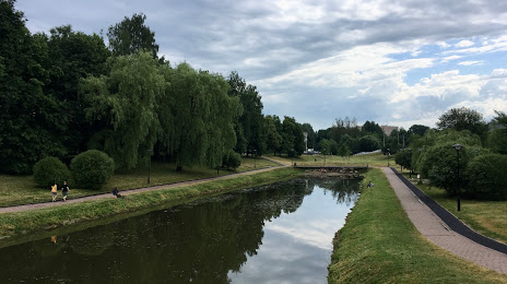
Photo
Where is located Park Imeni 1100 Letiya Smolenska
Park Imeni 1100 Letiya Smolenska — local attraction, which is located at Smolensk, Smolensk Oblast, 214020 and belongs to the category — park. Average visitor rating for this place — 4.3 (according to 3065 ratings, information from open sources and relevant for 2022).
Exact location — Park Imeni 1100 Letiya Smolenska, marked on the map with a red marker.
You can get directions to Park Imeni 1100 Letiya Smolenska on the map from your location.
What else is interesting in Smolensk? You can see all the sights if you go to the city page.
Coordinates
Park Imeni 1100 Letiya Smolenska, Russian Federation coordinates in decimal format: latitude — 54.771079319059375, longitude — 32.0822244984175. When converted to degrees, minutes, seconds Park Imeni 1100 Letiya Smolenska has the following coordinates: 54°46′15.89 north latitude and 32°4′56.01 east longitude.
Nearby cities
The largest cities that are located nearby:
- Velikiye Luki — 195 km
- Bryansk — 230 km
- Navapolatsk
 (Belarus) — 233 km
 - Babruysk (Belarus) — 261 km
- Gomel (Belarus) — 269 km
- Kaluga — 273 km
- Obninsk — 290 km
- Minsk (Belarus) — 308 km
- Tver — 327 km
- Odintsovo — 339 km
- Maladzyechna (Belarus) — 340 km
- Serpukhov — 342 km
- Zelenograd — 345 km
- Podolsk — 352 km
- Khimki — 356 km
- Izmaylovo — 360 km
- Mazyr (Belarus) — 361 km
- Daugavpils
 (Latvia) — 362 km
 - Tula — 366 km
Distance to the capital
Distance to the capital (Moscow) is about — 367 km.