
 Mikhaylovka
Dyrestuy
Mikhaylovka
Mayskiy
Novobessergenevka
Tersky District
Lesnoy
Tertezh
Kuz'minskiye Otverzhki
Mikhaylovka
Dyrestuy
Mikhaylovka
Mayskiy
Novobessergenevka
Tersky District
Lesnoy
Tertezh
Kuz'minskiye Otverzhki
Lyublinskoye Ozero on the map, Zelenogorsk, Russian Federation
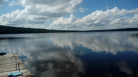
Photo
Where is located Lyublinskoye Ozero
Lyublinskoye Ozero — local attraction, which is located at no data and belongs to the category — -. Average visitor rating for this place — 4.5 (according to 24 ratings, information from open sources and relevant for 2022).
Exact location — Lyublinskoye Ozero, marked on the map with a red marker.
You can get directions to Lyublinskoye Ozero on the map from your location.
What else is interesting in Zelenogorsk? You can see all the sights if you go to the city page.
Coordinates
Lyublinskoye Ozero, Russian Federation coordinates in decimal format: latitude — 60.32405262939824, longitude — 29.90916661485493. When converted to degrees, minutes, seconds Lyublinskoye Ozero has the following coordinates: 60°19′26.59 north latitude and 29°54′33 east longitude.
Nearby cities
The largest cities that are located nearby:
- Saint Petersburg — 46 km
- Kolpino — 72 km
- Vantaa
 (Finland) — 256 km
 - Helsinki (Finland) — 262 km
- Tartu
 (Estonia) — 265 km
 - Pskov — 275 km
- Espoo (Finland) — 277 km
- Tallinn (Estonia) — 291 km
- Petrozavodsk — 299 km
- Tampere (Finland) — 345 km
- Turku (Finland) — 406 km
- Velikiye Luki — 430 km
- Cherepovets — 480 km
- Rīga
 (Latvia) — 493 km
 - Daugavpils (Latvia) — 517 km
- Navapolatsk
 (Belarus) — 523 km
 - Tver — 527 km
- Oulu (Finland) — 568 km
- Rybinsk — 585 km
Distance to the capital
Distance to the capital (Moscow) is about — 680 km.