
 Mikhaylovka
Dyrestuy
Mikhaylovka
Mayskiy
Novobessergenevka
Tersky District
Lesnoy
Tertezh
Kuz'minskiye Otverzhki
Mikhaylovka
Dyrestuy
Mikhaylovka
Mayskiy
Novobessergenevka
Tersky District
Lesnoy
Tertezh
Kuz'minskiye Otverzhki
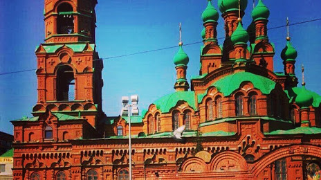
Svyato-Troitskiy Khram on the map, Chelyabinsk, Russian Federation
Photo
Where is located Svyato-Troitskiy Khram
Svyato-Troitskiy Khram — local attraction, which is located at Ulitsa Kirova, 60а, Chelyabinsk, Chelyabinsk Oblast, 454084 and belongs to the category — russian orthodox church. Average visitor rating for this place — 5.0 (according to 11 ratings, information from open sources and relevant for 2022).
Exact location — Svyato-Troitskiy Khram, marked on the map with a red marker.
You can get directions to Svyato-Troitskiy Khram on the map from your location.
What else is interesting in Chelyabinsk? You can see all the sights if you go to the city page.
Coordinates
Svyato-Troitskiy Khram, Russian Federation coordinates in decimal format: latitude — 55.17439441583865, longitude — 61.39902704843308. When converted to degrees, minutes, seconds Svyato-Troitskiy Khram has the following coordinates: 55°10′27.82 north latitude and 61°23′56.5 east longitude.
Nearby cities
The largest cities that are located nearby:
- Miass — 87 km
- Zlatoust — 112 km
- Yekaterinburg — 192 km
- Pervouralsk — 214 km
- Kurgan — 248 km
- Magnitogorsk — 252 km
- Kostanay
 (Kazakhstan) — 260 km
 - Tyumen — 330 km
- Ufa — 352 km
- Sterlitamak — 398 km
- Salavat — 414 km
- Perm — 434 km
- Neftekamsk — 453 km
- Orsk — 481 km
- Sarapul — 488 km
- Novotroitsk — 488 km
- Izhevsk — 532 km
- Berezniki — 538 km
- Solikamsk — 560 km
Distance to the capital
Distance to the capital (Moscow) is about — 1494 km.