
 Mikhaylovka
Dyrestuy
Mikhaylovka
Mayskiy
Novobessergenevka
Tersky District
Lesnoy
Tertezh
Kuz'minskiye Otverzhki
Mikhaylovka
Dyrestuy
Mikhaylovka
Mayskiy
Novobessergenevka
Tersky District
Lesnoy
Tertezh
Kuz'minskiye Otverzhki
Khram Aleksandra Nevskogo on the map, Chelyabinsk, Russian Federation
Photo
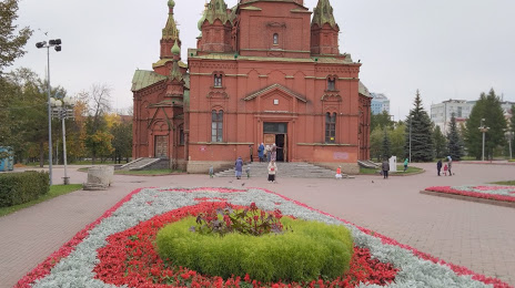
Where is located Khram Aleksandra Nevskogo
Khram Aleksandra Nevskogo — local attraction, which is located at ул. Алое Поле, 1, Chelyabinsk, Chelyabinsk Oblast, 454080 and belongs to the category — eastern orthodox church. Average visitor rating for this place — 4.5 (according to 243 ratings, information from open sources and relevant for 2022).
Exact location — Khram Aleksandra Nevskogo, marked on the map with a red marker.
You can get directions to Khram Aleksandra Nevskogo on the map from your location.
What else is interesting in Chelyabinsk? You can see all the sights if you go to the city page.
Coordinates
Khram Aleksandra Nevskogo, Russian Federation coordinates in decimal format: latitude — 55.16273790793978, longitude — 61.391023498432595. When converted to degrees, minutes, seconds Khram Aleksandra Nevskogo has the following coordinates: 55°9′45.86 north latitude and 61°23′27.68 east longitude.
Nearby cities
The largest cities that are located nearby:
- Miass — 87 km
- Zlatoust — 112 km
- Yekaterinburg — 192 km
- Pervouralsk — 214 km
- Kurgan — 248 km
- Magnitogorsk — 252 km
- Kostanay
 (Kazakhstan) — 260 km
 - Tyumen — 330 km
- Ufa — 352 km
- Sterlitamak — 398 km
- Salavat — 414 km
- Perm — 434 km
- Neftekamsk — 453 km
- Orsk — 481 km
- Sarapul — 488 km
- Novotroitsk — 488 km
- Izhevsk — 532 km
- Berezniki — 538 km
- Solikamsk — 560 km
Distance to the capital
Distance to the capital (Moscow) is about — 1493 km.