
 Mikhaylovka
Dyrestuy
Mikhaylovka
Mayskiy
Novobessergenevka
Tersky District
Lesnoy
Tertezh
Kuz'minskiye Otverzhki
Mikhaylovka
Dyrestuy
Mikhaylovka
Mayskiy
Novobessergenevka
Tersky District
Lesnoy
Tertezh
Kuz'minskiye Otverzhki
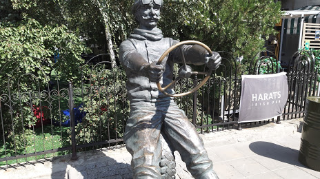
Pamyatnik Avtomobilistu on the map, Volgograd, Russian Federation
Photo
Where is located Pamyatnik Avtomobilistu
Pamyatnik Avtomobilistu — local attraction, which is located at Ulitsa Komsomol'skaya, 4, Volgograd, Volgograd Oblast, 400131 and belongs to the category — tourist attraction. Average visitor rating for this place — 5.0 (according to 1 rating, information from open sources and relevant for 2022).
Exact location — Pamyatnik Avtomobilistu, marked on the map with a red marker.
You can get directions to Pamyatnik Avtomobilistu on the map from your location.
What else is interesting in Volgograd? You can see all the sights if you go to the city page.
Coordinates
Pamyatnik Avtomobilistu, Russian Federation coordinates in decimal format: latitude — 48.70810195742672, longitude — 44.522512798194015. When converted to degrees, minutes, seconds Pamyatnik Avtomobilistu has the following coordinates: 48°42′29.17 north latitude and 44°31′21.05 east longitude.
Nearby cities
The largest cities that are located nearby:
- Volzhskiy — 20 km
- Kamyshin — 165 km
- Volgodonsk — 219 km
- Elista — 264 km
- Engels — 329 km
- Saratov — 330 km
- Shakhty — 337 km
- Novocherkassk — 361 km
- Astrakhan — 374 km
- Luhansk
 — 381 km
 - Bataysk — 399 km
- Alchevs'k — 420 km
- Balakovo — 430 km
- Stavropol — 449 km
- Taganrog — 451 km
- Horlivka — 479 km
- Tambov — 490 km
- Voronezh — 491 km
- Nevinnomyssk — 493 km
Distance to the capital
Distance to the capital (Moscow) is about — 913 km.