
 Mikhaylovka
Dyrestuy
Mikhaylovka
Mayskiy
Novobessergenevka
Tersky District
Lesnoy
Tertezh
Kuz'minskiye Otverzhki
Mikhaylovka
Dyrestuy
Mikhaylovka
Mayskiy
Novobessergenevka
Tersky District
Lesnoy
Tertezh
Kuz'minskiye Otverzhki
Simbirskaya Photo on the map, Ulyanovsk, Russian Federation
Photo
Where is located Simbirskaya Photo
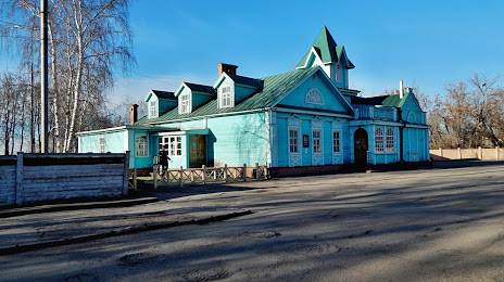
Simbirskaya Photo — local attraction, which is located at Ulitsa Engel'sa, 1Б, Ulyanovsk, Ulyanovsk Oblast, 432063 and belongs to the category — museum. Average visitor rating for this place — 4.8 (according to 104 ratings, information from open sources and relevant for 2022).
Exact location — Simbirskaya Photo, marked on the map with a red marker.
You can get directions to Simbirskaya Photo on the map from your location.
What else is interesting in Ulyanovsk? You can see all the sights if you go to the city page.
Coordinates
Simbirskaya Photo, Russian Federation coordinates in decimal format: latitude — 54.31535947520568, longitude — 48.39330847480147. When converted to degrees, minutes, seconds Simbirskaya Photo has the following coordinates: 54°18′55.29 north latitude and 48°23′35.91 east longitude.
Nearby cities
The largest cities that are located nearby:
- Dimitrovgrad — 78 km
- Tolyatti — 113 km
- Syzran — 127 km
- Kazan — 170 km
- Zelenodolsk — 170 km
- Novokuybyshevsk — 170 km
- Samara — 170 km
- Novocheboksarsk — 205 km
- Saransk — 207 km
- Cheboksary — 214 km
- Penza — 254 km
- Balakovo — 256 km
- Yoshkar-Ola — 258 km
- Almetyevsk — 259 km
- Nizhnekamsk — 260 km
- Arzamas — 310 km
- Saratov — 348 km
- Engels — 348 km
- Dzerzhinsk — 369 km
Distance to the capital
Distance to the capital (Moscow) is about — 705 km.