
 Mikhaylovka
Dyrestuy
Mikhaylovka
Mayskiy
Novobessergenevka
Tersky District
Lesnoy
Tertezh
Kuz'minskiye Otverzhki
Mikhaylovka
Dyrestuy
Mikhaylovka
Mayskiy
Novobessergenevka
Tersky District
Lesnoy
Tertezh
Kuz'minskiye Otverzhki
Staryy Surgut on the map, Surgut, Russian Federation
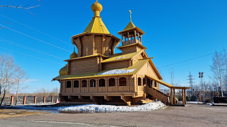
Photo
Where is located Staryy Surgut
Staryy Surgut — local attraction, which is located at Ulitsa Energetikov, 2, Surgut, Khanty-Mansi Autonomous Okrug, 628408 and belongs to the category — cultural center. Average visitor rating for this place — 4.6 (according to 1545 ratings, information from open sources and relevant for 2022).
Exact location — Staryy Surgut, marked on the map with a red marker.
You can get directions to Staryy Surgut on the map from your location.
What else is interesting in Surgut? You can see all the sights if you go to the city page.
Coordinates
Staryy Surgut, Russian Federation coordinates in decimal format: latitude — 61.237241302384916, longitude — 73.40741159867511. When converted to degrees, minutes, seconds Staryy Surgut has the following coordinates: 61°14′14.07 north latitude and 73°24′26.68 east longitude.
Nearby cities
The largest cities that are located nearby:
- Nefteyugansk — 49 km
- Nizhnevartovsk — 170 km
- Tyumen — 655 km
- Omsk — 693 km
- Kurgan — 816 km
- Seversk — 864 km
- Tomsk — 879 km
- Novosibirsk — 916 km
- Yekaterinburg — 916 km
- Kokshetau
 (Kazakhstan) — 919 km
 - Pervouralsk — 944 km
- Solikamsk — 949 km
- Berezniki — 958 km
- Ukhta — 1005 km
- Chelyabinsk — 1013 km
- Pavlodar (Kazakhstan) — 1019 km
- Ekibastuz (Kazakhstan) — 1061 km
- Norilsk — 1064 km
- Perm — 1065 km
Distance to the capital
Distance to the capital (Moscow) is about — 2137 km.