
 Mikhaylovka
Dyrestuy
Mikhaylovka
Mayskiy
Novobessergenevka
Tersky District
Lesnoy
Tertezh
Kuz'minskiye Otverzhki
Mikhaylovka
Dyrestuy
Mikhaylovka
Mayskiy
Novobessergenevka
Tersky District
Lesnoy
Tertezh
Kuz'minskiye Otverzhki
Petro-Pavlovskiy Sobor on the map, Perm, Russian Federation
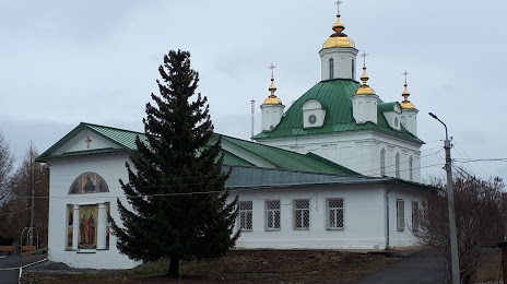
Photo
Where is located Petro-Pavlovskiy Sobor
Petro-Pavlovskiy Sobor — local attraction, which is located at Sovetskaya Ulitsa, 1, Perm, Perm Krai, 614045 and belongs to the category — church. Average visitor rating for this place — 4.9 (according to 66 ratings, information from open sources and relevant for 2022).
Exact location — Petro-Pavlovskiy Sobor, marked on the map with a red marker.
You can get directions to Petro-Pavlovskiy Sobor on the map from your location.
What else is interesting in Perm? You can see all the sights if you go to the city page.
Coordinates
Petro-Pavlovskiy Sobor, Russian Federation coordinates in decimal format: latitude — 58.01931511667605, longitude — 56.25563539854467. When converted to degrees, minutes, seconds Petro-Pavlovskiy Sobor has the following coordinates: 58°1′9.53 north latitude and 56°15′20.29 east longitude.
Nearby cities
The largest cities that are located nearby:
- Berezniki — 159 km
- Solikamsk — 183 km
- Glazov — 214 km
- Sarapul — 229 km
- Izhevsk — 229 km
- Neftekamsk — 244 km
- Pervouralsk — 250 km
- Yekaterinburg — 289 km
- Ufa — 361 km
- Zlatoust — 378 km
- Nizhnekamsk — 384 km
- Kirov — 389 km
- Miass — 409 km
- Almetyevsk — 427 km
- Chelyabinsk — 450 km
- Sterlitamak — 483 km
- Syktyvkar — 498 km
- Kazan — 509 km
- Salavat — 513 km
Distance to the capital
Distance to the capital (Moscow) is about — 1156 km.