
 Mikhaylovka
Dyrestuy
Mikhaylovka
Mayskiy
Novobessergenevka
Tersky District
Lesnoy
Tertezh
Kuz'minskiye Otverzhki
Mikhaylovka
Dyrestuy
Mikhaylovka
Mayskiy
Novobessergenevka
Tersky District
Lesnoy
Tertezh
Kuz'minskiye Otverzhki
Arkhitekturno-Etnograficheskiy Muzey Vologodskoy Oblasti on the map, Vologda, Russian Federation
Photo
Where is located Arkhitekturno-Etnograficheskiy Muzey Vologodskoy Oblasti
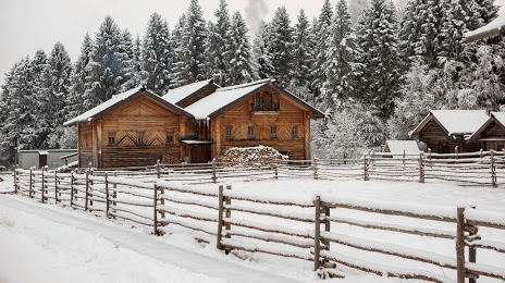
Arkhitekturno-Etnograficheskiy Muzey Vologodskoy Oblasti — local attraction, which is located at Semonkovo, Vologda Oblast, 160515 and belongs to the category — museum. Average visitor rating for this place — 5.0 (according to 25 ratings, information from open sources and relevant for 2022).
Exact location — Arkhitekturno-Etnograficheskiy Muzey Vologodskoy Oblasti, marked on the map with a red marker.
You can get directions to Arkhitekturno-Etnograficheskiy Muzey Vologodskoy Oblasti on the map from your location.
What else is interesting in Vologda? You can see all the sights if you go to the city page.
Coordinates
Arkhitekturno-Etnograficheskiy Muzey Vologodskoy Oblasti, Russian Federation coordinates in decimal format: latitude — 59.21721131696255, longitude — 39.89475019859263. When converted to degrees, minutes, seconds Arkhitekturno-Etnograficheskiy Muzey Vologodskoy Oblasti has the following coordinates: 59°13′1.96 north latitude and 39°53′41.1 east longitude.
Nearby cities
The largest cities that are located nearby:
- Cherepovets — 113 km
- Rybinsk — 143 km
- Kostroma — 172 km
- Yaroslavl — 176 km
- Kovrov — 327 km
- Vladimir — 341 km
- Tver — 355 km
- Pushkino — 378 km
- Noginsk — 380 km
- Orekhovo-Zuyevo — 382 km
- Elektrostal — 390 km
- Zelenograd — 393 km
- Balashikha — 395 km
- Dzerzhinsk — 396 km
- Khimki — 398 km
- Petrozavodsk — 406 km
- Lyubertsy — 410 km
- Murom — 425 km
- Odintsovo — 426 km
Distance to the capital
Distance to the capital (Moscow) is about — 408 km.