
 Mikhaylovka
Dyrestuy
Mikhaylovka
Mayskiy
Novobessergenevka
Tersky District
Lesnoy
Tertezh
Kuz'minskiye Otverzhki
Mikhaylovka
Dyrestuy
Mikhaylovka
Mayskiy
Novobessergenevka
Tersky District
Lesnoy
Tertezh
Kuz'minskiye Otverzhki
Arlekino on the map, Barnaul, Russian Federation
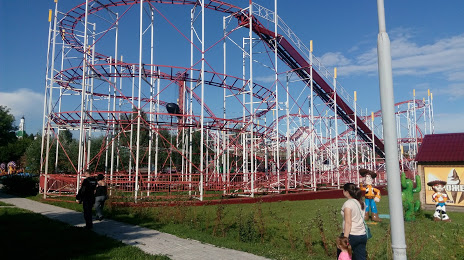
Photo
Where is located Arlekino
Arlekino — local attraction, which is located at Ulitsa Georgiya Isakova, 149А, Barnaul, Altai Krai, 656050 and belongs to the category — amusement park. Average visitor rating for this place — 4.6 (according to 3386 ratings, information from open sources and relevant for 2022).
Exact location — Arlekino, marked on the map with a red marker.
You can get directions to Arlekino on the map from your location.
What else is interesting in Barnaul? You can see all the sights if you go to the city page.
Coordinates
Arlekino, Russian Federation coordinates in decimal format: latitude — 53.3596956473682, longitude — 83.7130200983639. When converted to degrees, minutes, seconds Arlekino has the following coordinates: 53°21′34.9 north latitude and 83°42′46.87 east longitude.
Nearby cities
The largest cities that are located nearby:
- Biysk — 133 km
- Novosibirsk — 190 km
- Prokopyevsk — 201 km
- Leninsk-Kuznetskiy — 210 km
- Novokuznetsk — 224 km
- Rubtsovsk — 269 km
- Mezhdurechensk — 283 km
- Tomsk — 356 km
- Seversk — 365 km
- Oskemen
 (Kazakhstan) — 383 km
 - Semey (Kazakhstan) — 408 km
- Pavlodar (Kazakhstan) — 475 km
- Abakan — 502 km
- Achinsk — 523 km
- Ekibastuz (Kazakhstan) — 606 km
- Krasnoyarsk — 636 km
- Omsk — 684 km
- Altay
 (China) — 690 km
 - Kyzyl — 754 km
Distance to the capital
Distance to the capital (Moscow) is about — 2930 km.