
 Mikhaylovka
Dyrestuy
Mikhaylovka
Mayskiy
Novobessergenevka
Tersky District
Lesnoy
Tertezh
Kuz'minskiye Otverzhki
Mikhaylovka
Dyrestuy
Mikhaylovka
Mayskiy
Novobessergenevka
Tersky District
Lesnoy
Tertezh
Kuz'minskiye Otverzhki
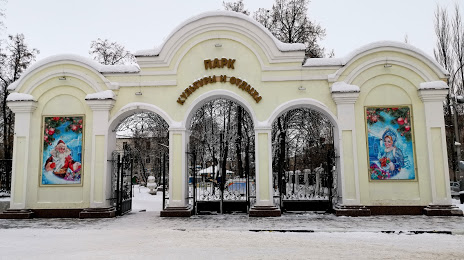
Park Kul'tury I Otdykha on the map, Michurinsk, Russian Federation
Photo
Where is located Park Kul'tury I Otdykha
Park Kul'tury I Otdykha — local attraction, which is located at Ulitsa Sovetskaya, 355 "а, Michurinsk, Tambov Oblast, 393760 and belongs to the category — park. Average visitor rating for this place — 4.4 (according to 920 ratings, information from open sources and relevant for 2022).
Exact location — Park Kul'tury I Otdykha, marked on the map with a red marker.
You can get directions to Park Kul'tury I Otdykha on the map from your location.
What else is interesting in Michurinsk? You can see all the sights if you go to the city page.
Coordinates
Park Kul'tury I Otdykha, Russian Federation coordinates in decimal format: latitude — 52.88674191208839, longitude — 40.51739469834606. When converted to degrees, minutes, seconds Park Kul'tury I Otdykha has the following coordinates: 52°53′12.27 north latitude and 40°31′2.62 east longitude.
Nearby cities
The largest cities that are located nearby:
- Tambov — 66 km
- Lipetsk — 68 km
- Yelets — 137 km
- Voronezh — 161 km
- Novomoskovsk — 189 km
- Ryazan — 196 km
- Tula — 236 km
- Kolomna — 267 km
- Serpukhov — 297 km
- Penza — 301 km
- Murom — 311 km
- Kursk — 325 km
- Kaluga — 327 km
- Saransk — 335 km
- Orekhovo-Zuyevo — 335 km
- Podolsk — 336 km
- Elektrostal — 344 km
- Izmaylovo — 345 km
- Arzamas — 347 km
Distance to the capital
Distance to the capital (Moscow) is about — 370 km.