
 Mikhaylovka
Dyrestuy
Mikhaylovka
Mayskiy
Novobessergenevka
Tersky District
Lesnoy
Tertezh
Kuz'minskiye Otverzhki
Mikhaylovka
Dyrestuy
Mikhaylovka
Mayskiy
Novobessergenevka
Tersky District
Lesnoy
Tertezh
Kuz'minskiye Otverzhki
Bogorodichnyy Shcheglovskiy Monastyr' on the map, Tula, Russian Federation
Photo
Where is located Bogorodichnyy Shcheglovskiy Monastyr'
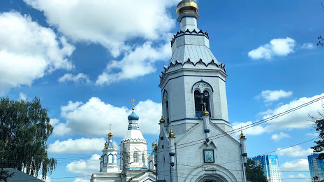
Bogorodichnyy Shcheglovskiy Monastyr' — local attraction, which is located at Lizy Chaykinoy Ulitsa, 1, Tula, Tula Oblast, 300004 and belongs to the category — monastery. Average visitor rating for this place — 4.7 (according to 515 ratings, information from open sources and relevant for 2022).
Exact location — Bogorodichnyy Shcheglovskiy Monastyr', marked on the map with a red marker.
You can get directions to Bogorodichnyy Shcheglovskiy Monastyr' on the map from your location.
What else is interesting in Tula? You can see all the sights if you go to the city page.
Coordinates
Bogorodichnyy Shcheglovskiy Monastyr', Russian Federation coordinates in decimal format: latitude — 54.211821322238166, longitude — 37.67577869839613. When converted to degrees, minutes, seconds Bogorodichnyy Shcheglovskiy Monastyr' has the following coordinates: 54°12′42.56 north latitude and 37°40′32.8 east longitude.
Nearby cities
The largest cities that are located nearby:
- Novomoskovsk — 49 km
- Serpukhov — 80 km
- Kaluga — 94 km
- Obninsk — 120 km
- Kolomna — 122 km
- Podolsk — 136 km
- Ryazan — 141 km
- Izmaylovo — 150 km
- Odintsovo — 163 km
- Lyubertsy — 165 km
- Balashikha — 180 km
- Elektrostal — 182 km
- Yelets — 185 km
- Khimki — 187 km
- Noginsk — 192 km
- Orekhovo-Zuyevo — 195 km
- Pushkino — 199 km
- Zelenograd — 200 km
- Lipetsk — 221 km
Distance to the capital
Distance to the capital (Moscow) is about — 172 km.