
 Mikhaylovka
Dyrestuy
Mikhaylovka
Mayskiy
Novobessergenevka
Tersky District
Lesnoy
Tertezh
Kuz'minskiye Otverzhki
Mikhaylovka
Dyrestuy
Mikhaylovka
Mayskiy
Novobessergenevka
Tersky District
Lesnoy
Tertezh
Kuz'minskiye Otverzhki
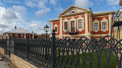
Centr semejnoj istorii — filial Muzeya-zapovednika V.D. Polenova S on the map, Tula, Russian Federation
Photo
Where is located Centr semejnoj istorii — filial Muzeya-zapovednika V.D. Polenova S
Centr semejnoj istorii — filial Muzeya-zapovednika V.D. Polenova S — local attraction, which is located at Blagoveshchenskaya Ulitsa, 8, Tula, Tula Oblast, 300041 and belongs to the category — museum. Average visitor rating for this place — 3.0 (according to 2 ratings, information from open sources and relevant for 2022).
Exact location — Centr semejnoj istorii — filial Muzeya-zapovednika V.D. Polenova S, marked on the map with a red marker.
You can get directions to Centr semejnoj istorii — filial Muzeya-zapovednika V.D. Polenova S on the map from your location.
What else is interesting in Tula? You can see all the sights if you go to the city page.
Coordinates
Centr semejnoj istorii — filial Muzeya-zapovednika V.D. Polenova S, Russian Federation coordinates in decimal format: latitude — 54.19769117266926, longitude — 37.615913698395715. When converted to degrees, minutes, seconds Centr semejnoj istorii — filial Muzeya-zapovednika V.D. Polenova S has the following coordinates: 54°11′51.69 north latitude and 37°36′57.29 east longitude.
Nearby cities
The largest cities that are located nearby:
- Novomoskovsk — 49 km
- Serpukhov — 80 km
- Kaluga — 94 km
- Obninsk — 120 km
- Kolomna — 122 km
- Podolsk — 136 km
- Ryazan — 141 km
- Izmaylovo — 150 km
- Odintsovo — 163 km
- Lyubertsy — 165 km
- Balashikha — 180 km
- Elektrostal — 182 km
- Yelets — 185 km
- Khimki — 187 km
- Noginsk — 192 km
- Orekhovo-Zuyevo — 195 km
- Pushkino — 199 km
- Zelenograd — 200 km
- Lipetsk — 221 km
Distance to the capital
Distance to the capital (Moscow) is about — 173 km.