
 Mikhaylovka
Dyrestuy
Mikhaylovka
Mayskiy
Novobessergenevka
Tersky District
Lesnoy
Tertezh
Kuz'minskiye Otverzhki
Mikhaylovka
Dyrestuy
Mikhaylovka
Mayskiy
Novobessergenevka
Tersky District
Lesnoy
Tertezh
Kuz'minskiye Otverzhki
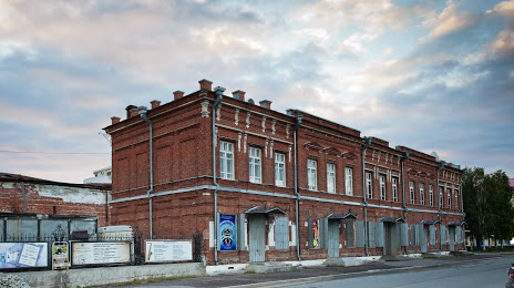
Art Museum of the Arctic exploration im.A A Borisova on the map, Arkhangelsk, Russian Federation
Photo
Where is located Art Museum of the Arctic exploration im.A A Borisova
Art Museum of the Arctic exploration im.A A Borisova — local attraction, which is located at Ulitsa Pomorskaya, 3, Arkhangelsk, Arkhangelsk Oblast, 163100 and belongs to the category — art museum. Average visitor rating for this place — 4.9 (according to 104 ratings, information from open sources and relevant for 2022).
Exact location — Art Museum of the Arctic exploration im.A A Borisova, marked on the map with a red marker.
You can get directions to Art Museum of the Arctic exploration im.A A Borisova on the map from your location.
What else is interesting in Arkhangelsk? You can see all the sights if you go to the city page.
Coordinates
Art Museum of the Arctic exploration im.A A Borisova, Russian Federation coordinates in decimal format: latitude — 64.53408329234429, longitude — 40.522682798812845. When converted to degrees, minutes, seconds Art Museum of the Arctic exploration im.A A Borisova has the following coordinates: 64°32′2.7 north latitude and 40°31′21.66 east longitude.
Nearby cities
The largest cities that are located nearby:
- Severodvinsk — 33 km
- Petrozavodsk — 446 km
- Vologda — 590 km
- Cherepovets — 617 km
- Syktyvkar — 625 km
- Ukhta — 656 km
- Oulu
 (Finland) — 707 km
 - Rybinsk — 725 km
- Kostroma — 750 km
- Saint Petersburg — 762 km
- Yaroslavl — 766 km
- Kolpino — 769 km
- Kirov — 841 km
- Tver — 895 km
- Kovrov — 906 km
- Vladimir — 929 km
- Dzerzhinsk — 936 km
- Tampere (Finland) — 948 km
- Pushkino — 960 km
Distance to the capital
Distance to the capital (Moscow) is about — 989 km.