
 Mikhaylovka
Dyrestuy
Mikhaylovka
Mayskiy
Novobessergenevka
Tersky District
Lesnoy
Tertezh
Kuz'minskiye Otverzhki
Mikhaylovka
Dyrestuy
Mikhaylovka
Mayskiy
Novobessergenevka
Tersky District
Lesnoy
Tertezh
Kuz'minskiye Otverzhki
Svyato-Nikol'skiy Khram on the map, Arkhangelsk, Russian Federation
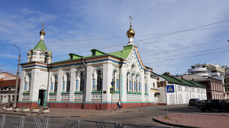
Photo
Where is located Svyato-Nikol'skiy Khram
Svyato-Nikol'skiy Khram — local attraction, which is located at Naberezhnaya Severnoy Dviny, 74, Arkhangelsk, Arkhangelsk Oblast, 163000 and belongs to the category — historical landmark. Average visitor rating for this place — 4.6 (according to 8 ratings, information from open sources and relevant for 2022).
Exact location — Svyato-Nikol'skiy Khram, marked on the map with a red marker.
You can get directions to Svyato-Nikol'skiy Khram on the map from your location.
What else is interesting in Arkhangelsk? You can see all the sights if you go to the city page.
Coordinates
Svyato-Nikol'skiy Khram, Russian Federation coordinates in decimal format: latitude — 64.53389329309903, longitude — 40.52016799881286. When converted to degrees, minutes, seconds Svyato-Nikol'skiy Khram has the following coordinates: 64°32′2.02 north latitude and 40°31′12.6 east longitude.
Nearby cities
The largest cities that are located nearby:
- Severodvinsk — 33 km
- Petrozavodsk — 446 km
- Vologda — 590 km
- Cherepovets — 617 km
- Syktyvkar — 625 km
- Ukhta — 656 km
- Oulu
 (Finland) — 707 km
 - Rybinsk — 725 km
- Kostroma — 750 km
- Saint Petersburg — 762 km
- Yaroslavl — 766 km
- Kolpino — 769 km
- Kirov — 841 km
- Tver — 895 km
- Kovrov — 906 km
- Vladimir — 929 km
- Dzerzhinsk — 936 km
- Tampere (Finland) — 948 km
- Pushkino — 960 km
Distance to the capital
Distance to the capital (Moscow) is about — 989 km.