
 Mikhaylovka
Dyrestuy
Mikhaylovka
Mayskiy
Novobessergenevka
Tersky District
Lesnoy
Tertezh
Kuz'minskiye Otverzhki
Mikhaylovka
Dyrestuy
Mikhaylovka
Mayskiy
Novobessergenevka
Tersky District
Lesnoy
Tertezh
Kuz'minskiye Otverzhki
Museum of the steel industry on the map, Cherepovets, Russian Federation
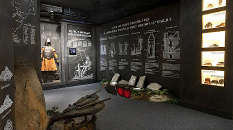
Photo
Where is located Museum of the steel industry
Museum of the steel industry — local attraction, which is located at Ulitsa Mira, 42, Cherepovets, Vologda Oblast, 162600 and belongs to the category — museum. Average visitor rating for this place — 4.6 (according to 568 ratings, information from open sources and relevant for 2022).
Exact location — Museum of the steel industry, marked on the map with a red marker.
You can get directions to Museum of the steel industry on the map from your location.
What else is interesting in Cherepovets? You can see all the sights if you go to the city page.
Coordinates
Museum of the steel industry, Russian Federation coordinates in decimal format: latitude — 59.133528533158405, longitude — 37.84594819858926. When converted to degrees, minutes, seconds Museum of the steel industry has the following coordinates: 59°8′0.7 north latitude and 37°50′45.41 east longitude.
Nearby cities
The largest cities that are located nearby:
- Vologda — 113 km
- Rybinsk — 131 km
- Yaroslavl — 203 km
- Kostroma — 234 km
- Tver — 279 km
- Pushkino — 346 km
- Petrozavodsk — 348 km
- Zelenograd — 349 km
- Khimki — 359 km
- Noginsk — 362 km
- Vladimir — 365 km
- Balashikha — 367 km
- Kovrov — 371 km
- Elektrostal — 372 km
- Orekhovo-Zuyevo — 374 km
- Lyubertsy — 381 km
- Odintsovo — 385 km
- Izmaylovo — 395 km
- Podolsk — 410 km
Distance to the capital
Distance to the capital (Moscow) is about — 376 km.