
 Mikhaylovka
Dyrestuy
Mikhaylovka
Mayskiy
Novobessergenevka
Tersky District
Lesnoy
Tertezh
Kuz'minskiye Otverzhki
Mikhaylovka
Dyrestuy
Mikhaylovka
Mayskiy
Novobessergenevka
Tersky District
Lesnoy
Tertezh
Kuz'minskiye Otverzhki
Lipetskiy Oblastnoy Krayevedcheskiy Muzey on the map, Lipetsk, Russian Federation
Photo
Where is located Lipetskiy Oblastnoy Krayevedcheskiy Muzey
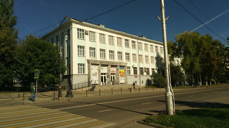
Lipetskiy Oblastnoy Krayevedcheskiy Muzey — local attraction, which is located at Ulitsa Lenina, 25, Lipetsk, Lipetsk Oblast, 398020 and belongs to the category — local history museum. Average visitor rating for this place — 4.4 (according to 249 ratings, information from open sources and relevant for 2022).
Exact location — Lipetskiy Oblastnoy Krayevedcheskiy Muzey, marked on the map with a red marker.
You can get directions to Lipetskiy Oblastnoy Krayevedcheskiy Muzey on the map from your location.
What else is interesting in Lipetsk? You can see all the sights if you go to the city page.
Coordinates
Lipetskiy Oblastnoy Krayevedcheskiy Muzey, Russian Federation coordinates in decimal format: latitude — 52.61413426692329, longitude — 39.60859969833586. When converted to degrees, minutes, seconds Lipetskiy Oblastnoy Krayevedcheskiy Muzey has the following coordinates: 52°36′50.88 north latitude and 39°36′30.96 east longitude.
Nearby cities
The largest cities that are located nearby:
- Yelets — 73 km
- Voronezh — 107 km
- Tambov — 123 km
- Novomoskovsk — 176 km
- Tula — 218 km
- Ryazan — 221 km
- Kursk — 256 km
- Kolomna — 279 km
- Serpukhov — 290 km
- Kaluga — 302 km
- Belgorod — 306 km
- Obninsk — 336 km
- Podolsk — 337 km
- Izmaylovo — 349 km
- Bryansk — 350 km
- Orekhovo-Zuyevo — 355 km
- Lyubertsy — 356 km
- Elektrostal — 358 km
- Murom — 360 km
Distance to the capital
Distance to the capital (Moscow) is about — 373 km.