
 Mikhaylovka
Dyrestuy
Mikhaylovka
Mayskiy
Novobessergenevka
Tersky District
Lesnoy
Tertezh
Kuz'minskiye Otverzhki
Mikhaylovka
Dyrestuy
Mikhaylovka
Mayskiy
Novobessergenevka
Tersky District
Lesnoy
Tertezh
Kuz'minskiye Otverzhki
Uspenskiy Sobor on the map, Tver, Russian Federation
Photo
Where is located Uspenskiy Sobor
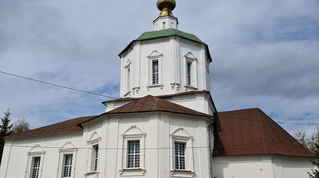
Uspenskiy Sobor — local attraction, which is located at Naberezhnaya Afanasiya Nikitina, 1, Tver, Tver Oblast, 170026 and belongs to the category — cathedral. Average visitor rating for this place — 4.6 (according to 46 ratings, information from open sources and relevant for 2022).
Exact location — Uspenskiy Sobor, marked on the map with a red marker.
You can get directions to Uspenskiy Sobor on the map from your location.
What else is interesting in Tver? You can see all the sights if you go to the city page.
Coordinates
Uspenskiy Sobor, Russian Federation coordinates in decimal format: latitude — 56.86488329794568, longitude — 35.91688329849899. When converted to degrees, minutes, seconds Uspenskiy Sobor has the following coordinates: 56°51′53.58 north latitude and 35°55′0.78 east longitude.
Nearby cities
The largest cities that are located nearby:
- Zelenograd — 124 km
- Khimki — 143 km
- Pushkino — 152 km
- Odintsovo — 156 km
- Balashikha — 172 km
- Lyubertsy — 179 km
- Izmaylovo — 179 km
- Podolsk — 188 km
- Noginsk — 192 km
- Obninsk — 197 km
- Elektrostal — 198 km
- Rybinsk — 216 km
- Orekhovo-Zuyevo — 223 km
- Serpukhov — 235 km
- Yaroslavl — 250 km
- Kaluga — 256 km
- Kolomna — 266 km
- Cherepovets — 276 km
- Vladimir — 288 km
Distance to the capital
Distance to the capital (Moscow) is about — 162 km.