
 Mikhaylovka
Dyrestuy
Mikhaylovka
Mayskiy
Novobessergenevka
Tersky District
Lesnoy
Tertezh
Kuz'minskiye Otverzhki
Mikhaylovka
Dyrestuy
Mikhaylovka
Mayskiy
Novobessergenevka
Tersky District
Lesnoy
Tertezh
Kuz'minskiye Otverzhki
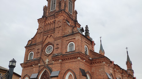
Katolicheskaya cerkov svyatogo Rozariya Presvyatoj Devy Marii Rimsko-katolicheskoj cerkvi on the map, Vladimir, Russian Federation
Photo
Where is located Katolicheskaya cerkov svyatogo Rozariya Presvyatoj Devy Marii Rimsko-katolicheskoj cerkvi
Katolicheskaya cerkov svyatogo Rozariya Presvyatoj Devy Marii Rimsko-katolicheskoj cerkvi — local attraction, which is located at Ulitsa Gogolya, 12, Vladimir, Vladimir Oblast, 600000 and belongs to the category — catholic church. Average visitor rating for this place — 4.9 (according to 157 ratings, information from open sources and relevant for 2022).
Exact location — Katolicheskaya cerkov svyatogo Rozariya Presvyatoj Devy Marii Rimsko-katolicheskoj cerkvi, marked on the map with a red marker.
You can get directions to Katolicheskaya cerkov svyatogo Rozariya Presvyatoj Devy Marii Rimsko-katolicheskoj cerkvi on the map from your location.
What else is interesting in Vladimir? You can see all the sights if you go to the city page.
Coordinates
Katolicheskaya cerkov svyatogo Rozariya Presvyatoj Devy Marii Rimsko-katolicheskoj cerkvi, Russian Federation coordinates in decimal format: latitude — 56.12507521227165, longitude — 40.39487079846999. When converted to degrees, minutes, seconds Katolicheskaya cerkov svyatogo Rozariya Presvyatoj Devy Marii Rimsko-katolicheskoj cerkvi has the following coordinates: 56°7′30.27 north latitude and 40°23′41.53 east longitude.
Nearby cities
The largest cities that are located nearby:
- Kovrov — 61 km
- Orekhovo-Zuyevo — 98 km
- Murom — 120 km
- Noginsk — 125 km
- Elektrostal — 128 km
- Kolomna — 156 km
- Balashikha — 157 km
- Pushkino — 161 km
- Lyubertsy — 165 km
- Yaroslavl — 167 km
- Ryazan — 176 km
- Kostroma — 182 km
- Izmaylovo — 185 km
- Khimki — 186 km
- Dzerzhinsk — 187 km
- Podolsk — 197 km
- Zelenograd — 200 km
- Odintsovo — 204 km
- Arzamas — 229 km
Distance to the capital
Distance to the capital (Moscow) is about — 178 km.