
 Mikhaylovka
Dyrestuy
Mikhaylovka
Mayskiy
Novobessergenevka
Tersky District
Lesnoy
Tertezh
Kuz'minskiye Otverzhki
Mikhaylovka
Dyrestuy
Mikhaylovka
Mayskiy
Novobessergenevka
Tersky District
Lesnoy
Tertezh
Kuz'minskiye Otverzhki
Stavropol'skiy Gosudarstvennyy Istoriko-Kul'turnyy I Prirodno-Landshaftnyy Muzey-Zapovednik on the map, Stavropol, Russian Federation
Photo
Where is located Stavropol'skiy Gosudarstvennyy Istoriko-Kul'turnyy I Prirodno-Landshaftnyy Muzey-Zapovednik
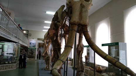
Stavropol'skiy Gosudarstvennyy Istoriko-Kul'turnyy I Prirodno-Landshaftnyy Muzey-Zapovednik — local attraction, which is located at Ulitsa Dzerzhinskogo, 135, Stavropol, Stavropol Krai, 355000 and belongs to the category — local history museum. Average visitor rating for this place — 4.7 (according to 274 ratings, information from open sources and relevant for 2022).
Exact location — Stavropol'skiy Gosudarstvennyy Istoriko-Kul'turnyy I Prirodno-Landshaftnyy Muzey-Zapovednik, marked on the map with a red marker.
You can get directions to Stavropol'skiy Gosudarstvennyy Istoriko-Kul'turnyy I Prirodno-Landshaftnyy Muzey-Zapovednik on the map from your location.
What else is interesting in Stavropol? You can see all the sights if you go to the city page.
Coordinates
Stavropol'skiy Gosudarstvennyy Istoriko-Kul'turnyy I Prirodno-Landshaftnyy Muzey-Zapovednik, Russian Federation coordinates in decimal format: latitude — 45.044823721013536, longitude — 41.96810859806841. When converted to degrees, minutes, seconds Stavropol'skiy Gosudarstvennyy Istoriko-Kul'turnyy I Prirodno-Landshaftnyy Muzey-Zapovednik has the following coordinates: 45°2′41.37 north latitude and 41°58′5.19 east longitude.
Nearby cities
The largest cities that are located nearby:
- Nevinnomyssk — 46 km
- Cherkessk — 92 km
- Kislovodsk — 138 km
- Pyatigorsk — 139 km
- Maykop — 158 km
- Nalchik — 217 km
- Elista — 224 km
- Krasnodar — 236 km
- Sochi — 243 km
- Volgodonsk — 272 km
- Bataysk — 286 km
- Novocherkassk — 298 km
- Nazran — 302 km
- Vladikavkaz — 311 km
- Kutaisi
 (Georgia) — 315 km
 - Shakhty — 321 km
- Taganrog — 332 km
- Novorossiysk — 335 km
- Batumi (Georgia) — 378 km
Distance to the capital
Distance to the capital (Moscow) is about — 1230 km.