
 Mikhaylovka
Dyrestuy
Mikhaylovka
Mayskiy
Novobessergenevka
Tersky District
Lesnoy
Tertezh
Kuz'minskiye Otverzhki
Mikhaylovka
Dyrestuy
Mikhaylovka
Mayskiy
Novobessergenevka
Tersky District
Lesnoy
Tertezh
Kuz'minskiye Otverzhki
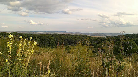
Tatarskoye Gorodishche on the map, Stavropol, Russian Federation
Photo
Where is located Tatarskoye Gorodishche
Tatarskoye Gorodishche — local attraction, which is located at Stavropol Krai, 356230 and belongs to the category — national forest. Average visitor rating for this place — 4.6 (according to 147 ratings, information from open sources and relevant for 2022).
Exact location — Tatarskoye Gorodishche, marked on the map with a red marker.
You can get directions to Tatarskoye Gorodishche on the map from your location.
What else is interesting in Stavropol? You can see all the sights if you go to the city page.
Coordinates
Tatarskoye Gorodishche, Russian Federation coordinates in decimal format: latitude — 44.976813932672336, longitude — 41.94350019806615. When converted to degrees, minutes, seconds Tatarskoye Gorodishche has the following coordinates: 44°58′36.53 north latitude and 41°56′36.6 east longitude.
Nearby cities
The largest cities that are located nearby:
- Nevinnomyssk — 46 km
- Cherkessk — 92 km
- Kislovodsk — 138 km
- Pyatigorsk — 139 km
- Maykop — 158 km
- Nalchik — 217 km
- Elista — 224 km
- Krasnodar — 236 km
- Sochi — 243 km
- Volgodonsk — 272 km
- Bataysk — 286 km
- Novocherkassk — 298 km
- Nazran — 302 km
- Vladikavkaz — 311 km
- Kutaisi
 (Georgia) — 315 km
 - Shakhty — 321 km
- Taganrog — 332 km
- Novorossiysk — 335 km
- Batumi (Georgia) — 378 km
Distance to the capital
Distance to the capital (Moscow) is about — 1237 km.