
 Mikhaylovka
Dyrestuy
Mikhaylovka
Mayskiy
Novobessergenevka
Tersky District
Lesnoy
Tertezh
Kuz'minskiye Otverzhki
Mikhaylovka
Dyrestuy
Mikhaylovka
Mayskiy
Novobessergenevka
Tersky District
Lesnoy
Tertezh
Kuz'minskiye Otverzhki
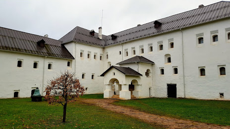
Pogankiny Palaty on the map, Pskov, Russian Federation
Photo
Where is located Pogankiny Palaty
Pogankiny Palaty — local attraction, which is located at 180000, Ulitsa Nekrasova, 7, Pskov, Pskov Oblast, 180000 and belongs to the category — museum. Average visitor rating for this place — 4.5 (according to 786 ratings, information from open sources and relevant for 2022).
Exact location — Pogankiny Palaty, marked on the map with a red marker.
You can get directions to Pogankiny Palaty on the map from your location.
What else is interesting in Pskov? You can see all the sights if you go to the city page.
Coordinates
Pogankiny Palaty, Russian Federation coordinates in decimal format: latitude — 57.81148529147324, longitude — 28.337467998536365. When converted to degrees, minutes, seconds Pogankiny Palaty has the following coordinates: 57°48′41.35 north latitude and 28°20′14.88 east longitude.
Nearby cities
The largest cities that are located nearby:
- Tartu
 (Estonia) — 112 km
 - Velikiye Luki — 212 km
- Daugavpils
 (Latvia) — 242 km
 - Kolpino — 247 km
- Navapolatsk
 (Belarus) — 255 km
 - Saint Petersburg — 259 km
- Tallinn (Estonia) — 269 km
- Rīga (Latvia) — 272 km
- Helsinki
 (Finland) — 320 km
 - Vantaa (Finland) — 328 km
- Espoo (Finland) — 333 km
- Panevėžys
 (Lithuania) — 338 km
 - Šiauliai (Lithuania) — 374 km
- Vilnius (Lithuania) — 397 km
- Maladzyechna (Belarus) — 399 km
- Smolensk — 410 km
- Kaunas (Lithuania) — 428 km
- Minsk (Belarus) — 435 km
- Turku (Finland) — 441 km
Distance to the capital
Distance to the capital (Moscow) is about — 609 km.