
 Mikhaylovka
Dyrestuy
Mikhaylovka
Mayskiy
Novobessergenevka
Tersky District
Lesnoy
Tertezh
Kuz'minskiye Otverzhki
Mikhaylovka
Dyrestuy
Mikhaylovka
Mayskiy
Novobessergenevka
Tersky District
Lesnoy
Tertezh
Kuz'minskiye Otverzhki
Monument to soldiers-drivers on the map, Bryansk, Russian Federation
Photo
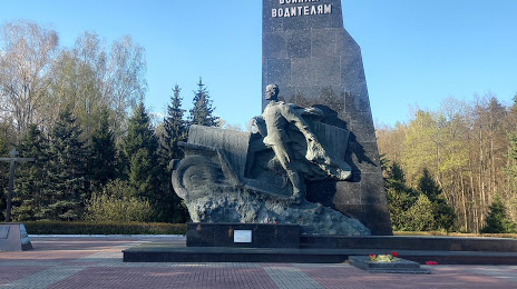
Where is located Monument to soldiers-drivers
Monument to soldiers-drivers — local attraction, which is located at P-120, Bryansk Oblast, 241004 and belongs to the category — memorial park. Average visitor rating for this place — 4.9 (according to 662 ratings, information from open sources and relevant for 2022).
Exact location — Monument to soldiers-drivers, marked on the map with a red marker.
You can get directions to Monument to soldiers-drivers on the map from your location.
What else is interesting in Bryansk? You can see all the sights if you go to the city page.
Coordinates
Monument to soldiers-drivers, Russian Federation coordinates in decimal format: latitude — 53.19863251544047, longitude — 34.529052998357834. When converted to degrees, minutes, seconds Monument to soldiers-drivers has the following coordinates: 53°11′55.08 north latitude and 34°31′44.59 east longitude.
Nearby cities
The largest cities that are located nearby:
- Kaluga — 186 km
- Kursk — 209 km
- Smolensk — 226 km
- Tula — 232 km
- Obninsk — 247 km
- Gomel
 (Belarus) — 248 km
 - Sumy
 (Ukraine) — 262 km
 - Serpukhov — 265 km
- Novomoskovsk — 265 km
- Yelets — 284 km
- Chernihiv (Ukraine) — 291 km
- Podolsk — 310 km
- Odintsovo — 320 km
- Izmaylovo — 324 km
- Belgorod — 332 km
- Kolomna — 342 km
- Babruysk (Belarus) — 345 km
- Lyubertsy — 345 km
- Khimki — 346 km
Distance to the capital
Distance to the capital (Moscow) is about — 347 km.