
 Mikhaylovka
Dyrestuy
Mikhaylovka
Mayskiy
Novobessergenevka
Tersky District
Lesnoy
Tertezh
Kuz'minskiye Otverzhki
Mikhaylovka
Dyrestuy
Mikhaylovka
Mayskiy
Novobessergenevka
Tersky District
Lesnoy
Tertezh
Kuz'minskiye Otverzhki
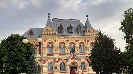
Kamyshinsky historical museum on the map, Kamyshin, Russian Federation
Photo
Where is located Kamyshinsky historical museum
Kamyshinsky historical museum — local attraction, which is located at Ulitsa Sovetskaya, 1, Kamyshin, Volgograd Oblast, 403893 and belongs to the category — museum. Average visitor rating for this place — 4.8 (according to 311 ratings, information from open sources and relevant for 2022).
Exact location — Kamyshinsky historical museum, marked on the map with a red marker.
You can get directions to Kamyshinsky historical museum on the map from your location.
What else is interesting in Kamyshin? You can see all the sights if you go to the city page.
Coordinates
Kamyshinsky historical museum, Russian Federation coordinates in decimal format: latitude — 50.07822348038526, longitude — 45.411814398242946. When converted to degrees, minutes, seconds Kamyshinsky historical museum has the following coordinates: 50°4′41.6 north latitude and 45°24′42.53 east longitude.
Nearby cities
The largest cities that are located nearby:
- Volzhskiy — 149 km
- Engels — 164 km
- Saratov — 166 km
- Volgograd — 166 km
- Balakovo — 270 km
- Penza — 346 km
- Volgodonsk — 373 km
- Tambov — 394 km
- Syzran — 397 km
- Elista — 425 km
- Novokuybyshevsk — 449 km
- Saransk — 454 km
- Astrakhan — 459 km
- Voronezh — 460 km
- Tolyatti — 462 km
- Shakhty — 466 km
- Samara — 466 km
- Luhansk
 — 476 km
 - Lipetsk — 479 km
Distance to the capital
Distance to the capital (Moscow) is about — 819 km.