
 Mikhaylovka
Dyrestuy
Mikhaylovka
Mayskiy
Novobessergenevka
Tersky District
Lesnoy
Tertezh
Kuz'minskiye Otverzhki
Mikhaylovka
Dyrestuy
Mikhaylovka
Mayskiy
Novobessergenevka
Tersky District
Lesnoy
Tertezh
Kuz'minskiye Otverzhki
Mountain Golukhov on the map, Miass, Russian Federation
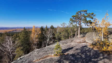
Photo
Where is located Mountain Golukhov
Mountain Golukhov — local attraction, which is located at Miass, Chelyabinsk Oblast, 456388 and belongs to the category — wildlife refuge. Average visitor rating for this place — 4.9 (according to 43 ratings, information from open sources and relevant for 2022).
Exact location — mountain Golukhov, marked on the map with a red marker.
You can get directions to Mountain Golukhov on the map from your location.
What else is interesting in Miass? You can see all the sights if you go to the city page.
Coordinates
mountain Golukhov, Russian Federation coordinates in decimal format: latitude — 54.907014530060145, longitude — 60.10409189842283. When converted to degrees, minutes, seconds mountain Golukhov has the following coordinates: 54°54′25.25 north latitude and 60°6′14.73 east longitude.
Nearby cities
The largest cities that are located nearby:
- Zlatoust — 33 km
- Chelyabinsk — 86 km
- Magnitogorsk — 190 km
- Yekaterinburg — 206 km
- Pervouralsk — 212 km
- Ufa — 265 km
- Kostanay
 (Kazakhstan) — 306 km
 - Sterlitamak — 311 km
- Salavat — 329 km
- Kurgan — 333 km
- Neftekamsk — 379 km
- Perm — 399 km
- Tyumen — 404 km
- Sarapul — 418 km
- Orsk — 433 km
- Novotroitsk — 438 km
- Izhevsk — 465 km
- Orenburg — 495 km
- Almetyevsk — 495 km
Distance to the capital
Distance to the capital (Moscow) is about — 1420 km.