
 Mikhaylovka
Dyrestuy
Mikhaylovka
Mayskiy
Novobessergenevka
Tersky District
Lesnoy
Tertezh
Kuz'minskiye Otverzhki
Mikhaylovka
Dyrestuy
Mikhaylovka
Mayskiy
Novobessergenevka
Tersky District
Lesnoy
Tertezh
Kuz'minskiye Otverzhki
Gora Syrkashi on the map, Mezhdurechensk, Russian Federation
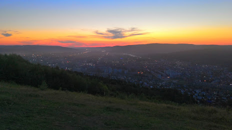
Photo
Where is located Gora Syrkashi
Gora Syrkashi — local attraction, which is located at Mezhdurechensk, Kemerovo Oblast, 652880 and belongs to the category — hiking area. Average visitor rating for this place — 4.9 (according to 115 ratings, information from open sources and relevant for 2022).
Exact location — Gora Syrkashi, marked on the map with a red marker.
You can get directions to Gora Syrkashi on the map from your location.
What else is interesting in Mezhdurechensk? You can see all the sights if you go to the city page.
Coordinates
Gora Syrkashi, Russian Federation coordinates in decimal format: latitude — 53.66559942442868, longitude — 88.09784442440551. When converted to degrees, minutes, seconds Gora Syrkashi has the following coordinates: 53°39′56.16 north latitude and 88°5′52.24 east longitude.
Nearby cities
The largest cities that are located nearby:
- Novokuznetsk — 61 km
- Prokopyevsk — 90 km
- Leninsk-Kuznetskiy — 162 km
- Abakan — 220 km
- Biysk — 229 km
- Barnaul — 285 km
- Achinsk — 321 km
- Novosibirsk — 356 km
- Tomsk — 363 km
- Seversk — 377 km
- Krasnoyarsk — 395 km
- Kyzyl — 489 km
- Rubtsovsk — 529 km
- Kansk — 548 km
- Oskemen
 (Kazakhstan) — 564 km
 - Altay
 (China) — 646 km
 - Semey (Kazakhstan) — 657 km
- Pavlodar (Kazakhstan) — 765 km
- Bratsk — 878 km
Distance to the capital
Distance to the capital (Moscow) is about — 3180 km.