
 Mikhaylovka
Dyrestuy
Mikhaylovka
Mayskiy
Novobessergenevka
Tersky District
Lesnoy
Tertezh
Kuz'minskiye Otverzhki
Mikhaylovka
Dyrestuy
Mikhaylovka
Mayskiy
Novobessergenevka
Tersky District
Lesnoy
Tertezh
Kuz'minskiye Otverzhki
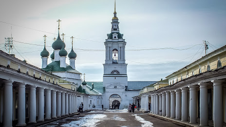
Church of the Saviour in the ranks on the map, Kostroma, Russian Federation
Photo
Where is located Church of the Saviour in the ranks
Church of the Saviour in the ranks — local attraction, which is located at Ulitsa Krasnyye Ryady, 1, Kostroma, Kostroma Oblast, 156000 and belongs to the category — church. Average visitor rating for this place — 4.7 (according to 103 ratings, information from open sources and relevant for 2022).
Exact location — Church of the Saviour in the ranks, marked on the map with a red marker.
You can get directions to Church of the Saviour in the ranks on the map from your location.
What else is interesting in Kostroma? You can see all the sights if you go to the city page.
Coordinates
Church of the Saviour in the ranks, Russian Federation coordinates in decimal format: latitude — 57.76584866137206, longitude — 40.92559899853457. When converted to degrees, minutes, seconds Church of the Saviour in the ranks has the following coordinates: 57°45′57.06 north latitude and 40°55′32.16 east longitude.
Nearby cities
The largest cities that are located nearby:
- Yaroslavl — 64 km
- Rybinsk — 127 km
- Kovrov — 157 km
- Vologda — 171 km
- Vladimir — 182 km
- Cherepovets — 229 km
- Dzerzhinsk — 229 km
- Orekhovo-Zuyevo — 249 km
- Murom — 253 km
- Noginsk — 259 km
- Elektrostal — 268 km
- Pushkino — 274 km
- Balashikha — 284 km
- Lyubertsy — 298 km
- Khimki — 299 km
- Zelenograd — 303 km
- Arzamas — 318 km
- Izmaylovo — 319 km
- Tver — 319 km
Distance to the capital
Distance to the capital (Moscow) is about — 301 km.