
 Mikhaylovka
Dyrestuy
Mikhaylovka
Mayskiy
Novobessergenevka
Tersky District
Lesnoy
Tertezh
Kuz'minskiye Otverzhki
Mikhaylovka
Dyrestuy
Mikhaylovka
Mayskiy
Novobessergenevka
Tersky District
Lesnoy
Tertezh
Kuz'minskiye Otverzhki
Skaly Petra Gronskogo on the map, Sredneuralsk, Russian Federation
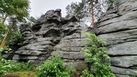
Photo
Where is located Skaly Petra Gronskogo
Skaly Petra Gronskogo — local attraction, which is located at Iset', Sverdlovsk Oblast, 624082 and belongs to the category — tourist attraction. Average visitor rating for this place — 4.9 (according to 243 ratings, information from open sources and relevant for 2022).
Exact location — Skaly Petra Gronskogo, marked on the map with a red marker.
You can get directions to Skaly Petra Gronskogo on the map from your location.
What else is interesting in Sredneuralsk? You can see all the sights if you go to the city page.
Coordinates
Skaly Petra Gronskogo, Russian Federation coordinates in decimal format: latitude — 56.99693811101344, longitude — 60.33909869850416. When converted to degrees, minutes, seconds Skaly Petra Gronskogo has the following coordinates: 56°59′48.98 north latitude and 60°20′20.76 east longitude.
Nearby cities
The largest cities that are located nearby:
- Yekaterinburg — 18 km
- Pervouralsk — 32 km
- Zlatoust — 207 km
- Chelyabinsk — 210 km
- Miass — 221 km
- Perm — 268 km
- Tyumen — 304 km
- Berezniki — 340 km
- Kurgan — 349 km
- Solikamsk — 360 km
- Ufa — 379 km
- Neftekamsk — 393 km
- Magnitogorsk — 406 km
- Sarapul — 411 km
- Izhevsk — 441 km
- Kostanay
 (Kazakhstan) — 466 km
 - Glazov — 473 km
- Sterlitamak — 474 km
- Salavat — 499 km
Distance to the capital
Distance to the capital (Moscow) is about — 1400 km.