
 Mikhaylovka
Dyrestuy
Mikhaylovka
Mayskiy
Novobessergenevka
Tersky District
Lesnoy
Tertezh
Kuz'minskiye Otverzhki
Mikhaylovka
Dyrestuy
Mikhaylovka
Mayskiy
Novobessergenevka
Tersky District
Lesnoy
Tertezh
Kuz'minskiye Otverzhki
Gora Tarki-Tau on the map, Makhachkala, Russian Federation
Photo
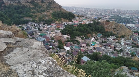
Where is located Gora Tarki-Tau
Gora Tarki-Tau — local attraction, which is located at Makhachkala, Republic of Dagestan, 367015 and belongs to the category — rest stop. Average visitor rating for this place — 4.7 (according to 48 ratings, information from open sources and relevant for 2022).
Exact location — Gora Tarki-Tau, marked on the map with a red marker.
You can get directions to Gora Tarki-Tau on the map from your location.
What else is interesting in Makhachkala? You can see all the sights if you go to the city page.
Coordinates
Gora Tarki-Tau, Russian Federation coordinates in decimal format: latitude — 42.94381919164166, longitude — 47.46316529621068. When converted to degrees, minutes, seconds Gora Tarki-Tau has the following coordinates: 42°56′37.75 north latitude and 47°27′47.4 east longitude.
Nearby cities
The largest cities that are located nearby:
- Khasavyurt — 80 km
- Derbent — 121 km
- Nazran — 222 km
- Vladikavkaz — 230 km
- Tbilisi
 (Georgia) — 263 km
 - Aktau
 (Kazakhstan) — 305 km
 - Nalchik — 317 km
- Baku
 (Azerbaijan) — 346 km
 - Vanadzor
 (Armenia) — 347 km
 - Parsabad
 (Iran) — 369 km
 - Pyatigorsk — 373 km
- Astrakhan — 377 km
- Gyumri (Armenia) — 389 km
- Kislovodsk — 395 km
- Yerevan (Armenia) — 398 km
- Kutaisi (Georgia) — 401 km
- Elista — 445 km
- Cherkessk — 453 km
- Nevinnomyssk — 475 km
Distance to the capital
Distance to the capital (Moscow) is about — 1590 km.