
 Mikhaylovka
Dyrestuy
Mikhaylovka
Mayskiy
Novobessergenevka
Tersky District
Lesnoy
Tertezh
Kuz'minskiye Otverzhki
Mikhaylovka
Dyrestuy
Mikhaylovka
Mayskiy
Novobessergenevka
Tersky District
Lesnoy
Tertezh
Kuz'minskiye Otverzhki
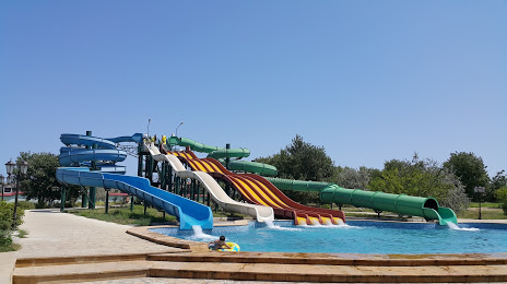
Akvalend on the map, Makhachkala, Russian Federation
Photo
Where is located Akvalend
Akvalend — local attraction, which is located at Республика Дагестан, Каспийск, шоссе Махачкала-Каспийск, 3а/8, Kaspiysk, Republic of Dagestan, 368300 and belongs to the category — water park. Average visitor rating for this place — 4.1 (according to 453 ratings, information from open sources and relevant for 2022).
Exact location — Akvalend, marked on the map with a red marker.
You can get directions to Akvalend on the map from your location.
What else is interesting in Makhachkala? You can see all the sights if you go to the city page.
Coordinates
Akvalend, Russian Federation coordinates in decimal format: latitude — 42.91210983746541, longitude — 47.620032597998886. When converted to degrees, minutes, seconds Akvalend has the following coordinates: 42°54′43.6 north latitude and 47°37′12.12 east longitude.
Nearby cities
The largest cities that are located nearby:
- Khasavyurt — 80 km
- Derbent — 121 km
- Nazran — 222 km
- Vladikavkaz — 230 km
- Tbilisi
 (Georgia) — 263 km
 - Aktau
 (Kazakhstan) — 305 km
 - Nalchik — 317 km
- Baku
 (Azerbaijan) — 346 km
 - Vanadzor
 (Armenia) — 347 km
 - Parsabad
 (Iran) — 369 km
 - Pyatigorsk — 373 km
- Astrakhan — 377 km
- Gyumri (Armenia) — 389 km
- Kislovodsk — 395 km
- Yerevan (Armenia) — 398 km
- Kutaisi (Georgia) — 401 km
- Elista — 445 km
- Cherkessk — 453 km
- Nevinnomyssk — 475 km
Distance to the capital
Distance to the capital (Moscow) is about — 1598 km.