
 Mikhaylovka
Dyrestuy
Mikhaylovka
Mayskiy
Novobessergenevka
Tersky District
Lesnoy
Tertezh
Kuz'minskiye Otverzhki
Mikhaylovka
Dyrestuy
Mikhaylovka
Mayskiy
Novobessergenevka
Tersky District
Lesnoy
Tertezh
Kuz'minskiye Otverzhki
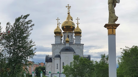
Preobrazhenskiy Park on the map, Abakan, Russian Federation
Photo
Where is located Preobrazhenskiy Park
Preobrazhenskiy Park — local attraction, which is located at Unnamed Road, Abakan, Republic of Khakassia, 655010 and belongs to the category — park. Average visitor rating for this place — 4.7 (according to 486 ratings, information from open sources and relevant for 2022).
Exact location — Preobrazhenskiy Park, marked on the map with a red marker.
You can get directions to Preobrazhenskiy Park on the map from your location.
What else is interesting in Abakan? You can see all the sights if you go to the city page.
Coordinates
Preobrazhenskiy Park, Russian Federation coordinates in decimal format: latitude — 53.74206109400765, longitude — 91.43085159837833. When converted to degrees, minutes, seconds Preobrazhenskiy Park has the following coordinates: 53°44′31.42 north latitude and 91°25′51.07 east longitude.
Nearby cities
The largest cities that are located nearby:
- Mezhdurechensk — 220 km
- Krasnoyarsk — 270 km
- Novokuznetsk — 281 km
- Achinsk — 286 km
- Kyzyl — 303 km
- Prokopyevsk — 307 km
- Leninsk-Kuznetskiy — 352 km
- Kansk — 381 km
- Biysk — 437 km
- Tomsk — 498 km
- Barnaul — 506 km
- Seversk — 511 km
- Novosibirsk — 556 km
- Bratsk — 682 km
- Altay
 (China) — 693 km
 - Rubtsovsk — 744 km
- Oskemen
 (Kazakhstan) — 751 km
 - Ust-Ilimsk — 812 km
- Angarsk — 849 km
Distance to the capital
Distance to the capital (Moscow) is about — 3374 km.