
 Mikhaylovka
Dyrestuy
Mikhaylovka
Mayskiy
Novobessergenevka
Tersky District
Lesnoy
Tertezh
Kuz'minskiye Otverzhki
Mikhaylovka
Dyrestuy
Mikhaylovka
Mayskiy
Novobessergenevka
Tersky District
Lesnoy
Tertezh
Kuz'minskiye Otverzhki
Amfiteatr on the map, Gatchina, Russian Federation
Photo
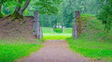
Where is located Amfiteatr
Amfiteatr — local attraction, which is located at Gatchina, Leningrad Oblast, 188307 and belongs to the category — historical landmark. Average visitor rating for this place — 4.2 (according to 53 ratings, information from open sources and relevant for 2022).
Exact location — Amfiteatr, marked on the map with a red marker.
You can get directions to Amfiteatr on the map from your location.
What else is interesting in Gatchina? You can see all the sights if you go to the city page.
Coordinates
Amfiteatr, Russian Federation coordinates in decimal format: latitude — 59.56686129283987, longitude — 30.097466798606828. When converted to degrees, minutes, seconds Amfiteatr has the following coordinates: 59°34′0.7 north latitude and 30°5′50.88 east longitude.
Nearby cities
The largest cities that are located nearby:
- Kolpino — 33 km
- Saint Petersburg — 43 km
- Pskov — 219 km
- Tartu
 (Estonia) — 236 km
 - Vantaa
 (Finland) — 289 km
 - Helsinki (Finland) — 292 km
- Tallinn (Estonia) — 301 km
- Espoo (Finland) — 308 km
- Petrozavodsk — 330 km
- Velikiye Luki — 357 km
- Tampere (Finland) — 397 km
- Turku (Finland) — 439 km
- Cherepovets — 445 km
- Navapolatsk
 (Belarus) — 458 km
 - Tver — 461 km
- Rīga
 (Latvia) — 463 km
 - Daugavpils (Latvia) — 464 km
- Rybinsk — 537 km
- Smolensk — 542 km
Distance to the capital
Distance to the capital (Moscow) is about — 616 km.