
 Mikhaylovka
Dyrestuy
Mikhaylovka
Mayskiy
Novobessergenevka
Tersky District
Lesnoy
Tertezh
Kuz'minskiye Otverzhki
Mikhaylovka
Dyrestuy
Mikhaylovka
Mayskiy
Novobessergenevka
Tersky District
Lesnoy
Tertezh
Kuz'minskiye Otverzhki
Angara village on the map, Bratsk, Russian Federation
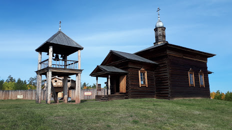
Photo
Where is located Angara village
Angara village — local attraction, which is located at Падунская трасса, Irkutsk Oblast, 665712 and belongs to the category — museum. Average visitor rating for this place — 4.7 (according to 464 ratings, information from open sources and relevant for 2022).
Exact location — Angara village, marked on the map with a red marker.
You can get directions to Angara village on the map from your location.
What else is interesting in Bratsk? You can see all the sights if you go to the city page.
Coordinates
Angara village, Russian Federation coordinates in decimal format: latitude — 56.22263415566242, longitude — 101.68161349847377. When converted to degrees, minutes, seconds Angara village has the following coordinates: 56°13′21.48 north latitude and 101°40′53.81 east longitude.
Nearby cities
The largest cities that are located nearby:
- Ust-Ilimsk — 217 km
- Kansk — 362 km
- Angarsk — 424 km
- Krasnoyarsk — 538 km
- Ulan-Ude — 628 km
- Achinsk — 682 km
- Kyzyl — 690 km
- Abakan — 717 km
- Chita — 924 km
- Mezhdurechensk — 927 km
- Novokuznetsk — 982 km
- Ulaanbaatar
 (Mongolia) — 988 km
 - Leninsk-Kuznetskiy — 1001 km
- Prokopyevsk — 1001 km
- Tomsk — 1014 km
- Seversk — 1021 km
- Biysk — 1171 km
- Novosibirsk — 1190 km
- Barnaul — 1216 km
Distance to the capital
Distance to the capital (Moscow) is about — 3839 km.